Route Editor

| Guide | ♦ | 10 Triplogs | 3 Topics |
details | drive | permit | forecast | route |
stats |
photos | triplogs | topics | location |
| 266 | 10 | 3 |
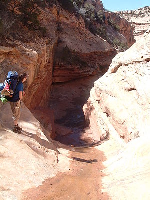
Canyons are inherently risky. Flash floods occur without notice on sunny days. Technical skills & surrounding topography knowledge required yet does not eliminate risk.
Multi-day backpack into Anasazi wilderness by PaleoRob  This trip can run in two directions - in at Kane Gulch Ranger Station, and out at Bullet Canyon, or vice versa. I did this trip from Bullet Canyon to Kane Gulch, so that is how this trip will be described. However, most backpackers do the trip in the opposite direction. The trail starts at the end of the Bullet Canyon road at a small, shaded, dirt parking lot. Make sure that you have your permit in hand from the ranger station. The trail takes off across the mesa heading west, paralleling the rim of Bullet Canyon. A short climb down a series of slickrock slides takes you to the bottom of Bullet Canyon.
After about a mile, the canyon begins to deepen noticeably, and about a mile and a half from the trailhead comes the section known as The Chutes. The first chute is a slickrock narrows with a 2-3 foot pourover, which can be generally easily navigated without much trouble. If it is icy, however, some concentration must be applied - this condition is most likely in the winter into the mid-spring. The second chute is not much farther downcanyon, and it is a monster boulder fall. The trail is indistinct approaching the chute, and the boulders offer few ways past. Keep a close eye on the trail and any cairns that may be visible, especially along the north side of the canyon approaching the chute. While passage through the heart of the boulder fall is possible, it is neither the easiest nor the most recommended method of passage. The third chute is a smaller boulder fall which is navigated with much greater ease than the second chute. The canyon opens up a bit after the chutes, and a few small, grassy meadows make excellent lunch spots. The Bullet Canyon's walls show their true height now, without the constriction or the foot-watching passage of the chutes. Perfect Kiva Ruin is in this section of Bullet Canyon - keep a sharp watch out for it and other ruins. Not far past Perfect Kiva, about 5 miles from the trailhead, you come to the first truly reliable water source in Bullet Canyon at Jailhouse Spring, across and just upcanyon from Jailhouse Ruin. The spring usually flows most of the year with a small stream heading for some distance downstream. If you miss the spring flowing over the slickrock, you can still fill your water bottles in the pools of the creek for the next half mile or so. Bullet Canyon nears its ends, with only about 2 miles to go until you reach the junction with Grand Gulch. There is a steep arroyo bank to negotiate about 3/4 of a mile from the junction, and provides a good view downcanyon towards the junction. There is another good spring at the junction, as well as good campsites. It can be easy to mistake the junction for just another side canyon. Make sure you are traveling with a good map and can recognize Grand Gulch branching north as well as heading due west, as though it was still part of Bullet Canyon. On our three-day trip, this is where we camped, and it was a good half day to cover the 7.2 miles from the trailhead to the junction. Starting from Bullet Canyon has its disadvantages. Once you reach the junction of Grand Gulch and Bullet Canyon, it is a slow uphill grade to the trailhead at Kane Gulch. The middle section, from Bullet Canyon up Grand Gulch to Todie Canyon is 8.4 miles, and with exploring a few side canyons and ruins, took the entire day, arriving at Todie Canyon just at sunset. This middle stretch was also the most chock-full of Anasazi ruins and rock art in the entire hike, to my eyes. While three days is the minimum to hike this stretch of canyon, a fourth day placed in the middle of the Bullet-Todie stretch would not be wasted by any means. It felt like there was not enough time for all we wanted to do. This section is not terribly hard, but instead of following the wash bottom, the trail continually snakes up and down over arroyo banks. While these never range much higher than 5 feet, the continual up and down can really wear down your knees and morale. Frequent stops are not to be overstated on this section. There were several long stretches of water in the wash, though stagnant, that would provide water if needed. However the springs up and below Todie Canyon, and in Sheiks's Canyon especially, provided lots of very sweet water. Shade can be harder to find on the upper section of this stretch during midday, as the sun is shining directly down into the canyon along its long axis - the walls provide nothing. If you have the time, explore. Todie Canyon provides good campsites and also provides a reminder of not to play with fire. A backpacking party set a large fire in the area while trying to burn their toilet paper some years ago. The blackened pinon and juniper still stand in the area, and also easily mark the entrance to Todie. Make sure and police your site as well - the grassy areas around Split Level Ruin look inviting, but are closed to camping due to overuse and abuse by other parties. Camping is not allowed within the area around Split Level, nor in the immediate area (bench/alcove/etc.) of any historic or prehistoric site. The third stretch takes you from Todie Canyon up Grand Gulch to the junction with Kane Gulch, and is about 7 miles, and took us half a day to cover this distance. The hiking is easy, with arroyo crossings steeper but less numerous, becoming almost non-existent in Kane Gulch. Ruins are plentiful in this stretch of canyon too, with some of the high points being Turkey Pen, where an 800-year-old turkey pen is preserved, and Junction Ruin, at the junction of Grand and Kane Gulches. Stimper Arch, a natural arch on a thin fin of rock is a neat sight to behold just downcanyon from Turkey Pen. This stretch of canyon only has one serious side-canyon, Fortress Canyon, to contend with. Not long after leaving Todie, Grand Gulch will bear to the northeast, while Fortress Canyon opens directly ahead to the north. Consult your map and compass, and it will provide no serious problem. Water is usually available at Junction Spring, just downcanyon from Junction Ruin. While water can sometimes be found Kane Gulch in a flowing creek or pothole, especially in the spring when snow is still melting, in the summer and fall these water sources are less likely to be present. It is only about 4 miles from the Junction to Kane Gulch Ranger Station, but there is a serious incline as you ascend back to the mesa top. Not long after entering Kane Gulch you find yourself at The Pourover, a series of slickrock pourovers climbing 200 feet in the space of half a mile, and climbing a further 200 feet before the remaining 3 miles are done. The first pourover is the most intimidating. The trail starts on the south side of the canyon, crosses over a dry (most of the time) fall, then switchbacks sharply up talus on the north side until reaching a slickrock bench. This pattern is generally repeated until The Pourover has been completely bypassed. You will know you are getting close to the trailhead as the canyon walls lessen. The trail ducks and climbs up behind a fallen boulder that had peeled off of the cliff face. At this point the mighty canyon walls are no higher than 30 feet, and soon you are walking through a stand of willows in a broad arroyo. The canyon is gone. Cross a slickrock plain, and duck across another arroyo, and you've arrived at Kane Gulch Ranger Station, where you can pick up your car shuttle and head back to Bullet Canyon to recover your other car. I have listed the hike at 26 miles. The strict map distance is 22.8. However, with sidecanyons, springs, and exploring, expect to go at least 26 miles before you are through. Check out the Official Route and Triplogs. Leave No Trace and +Add a Triplog after your canyon trip to support this local community. | |||||||||||||||||||||||||||||||||||||||||||||||||||||||||||||||||||||||||||||||||||||||||