Route Editor

| Guide | ♦ | 12 Triplogs | 1 Topic |
details | drive | permit | forecast | route |
stats |
photos | triplogs | topic | location |
| 187 | 12 | 1 |
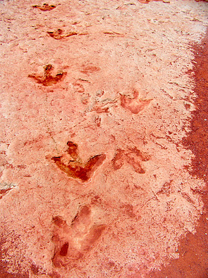
Walk where dinosaurs did! by PaleoRob   The Tuba City Dinosaur Track Site is one of the most famous well-known dinosaur trackways along Hamblin Ridge's bench. First discovered around the beginning of the 20th century, it has lived on to this day as a neat window into the past. The Tuba City Dinosaur Track Site is one of the most famous well-known dinosaur trackways along Hamblin Ridge's bench. First discovered around the beginning of the 20th century, it has lived on to this day as a neat window into the past.The tracks were formed in the early Jurassic period, about 202 to 200 million years ago. Their tracks represent several different types of dinosaurs, but all of them were carnivores. The ichnogenera include Eubrontes and Grallator. Fossil footprints, also called trace fossils, are classified not according to what animal created them but rather by their form. It's impossible to know for sure if two unrelated animals made similar tracks. Based on the age of the rocks and the fossils of carnivorous dinosaurs in the area, its likely that animals such as "Coelophysis kayentakatae and Dilophosaurus wetherilli made the tracks at the Tuba City site, as well as the other Dinosaur Canyon trackways. Both of these dinosaurs were discovered in the slightly younger overlaying Kayenta Formation. There is also a new dinosaur from the Moenave formation nicknamed "Dixiesaurus" from St. George, Utah, that likely would have lived here in Arizona.
Considering that, I'll point out some things that I've heard on my various trips that are not true. There are no T. rex tracks at this location or anywhere else in the Moenave Formation. T. rex lived 65 millions years ago. That means that these tracks were made 135 million years before T. rex ever walked the earth - more than double the amount time since T. rex has gone extinct! I've had "eggs" and "poop" (properly known as coprolites) pointed out to me before. Coprolites are not rare, but the rocks pointed out are just iron concretions in the sandstone that look like droppings. Eggs are relatively rare, especially whole eggs. No eggs from the earliest Jurassic are known in North America. Once again, the "eggs" shown are just iron concretions, frequently broken in half to reveal a hollow or discolored interior. Real fossil eggs do not have a hollow interior or a discoloration inside of them. Instead, they have a fragile and finely textured shell, with the rock matrix being the same inside and out. If you look on eBay, you'll notice many of these iron "eggs" being sold. I have also had a "skeleton" pointed out to me, supposedly still in the ground. It's just a neat looking weathered bit of sandstone. Occasionally, I'll hear that some university scientists came and stole one (or two) skeletons from right nearby during the night. It takes weeks to excavate a skeleton - even the shoddiest paleontologist wouldn't be able to dig up a whole skeleton overnight. During the 1940s, however, Sam Welles from the University of California Museum of Paleontology did excavate a skeleton of Dilophosaurus north and east of the track site, along the base of Hamblin Ridge. There is a real bone preserved in the sandstone of the Tuba City Track Site, and sometimes the guide will point it out, saying that it's a "raptor claw" or "T. rex tooth." It's neither of those. The closest guess I've heard from a paleontologist is that it's a lung-fish gill-plate. Not nearly as exciting. It does look very claw-like. There are other things I hear, but those are the most common mistakes. I think it's not deliberate lies to play upon the gullibility of the tourist population. Instead, it is likely a lack of knowledge from the guides that mirrors the general public's lack of knowledge. Most folks don't know if T. rex lived during the Jurassic or Cretaceous, regardless of where the people live and what the people do. As I said, some of the guides have gone to college to learn more or have consulted with paleontologists here in Northern Arizona. Just keep a skeptical ear open. Regardless of the guides' knowledge, the hike itself is painless and beautiful, with fabulous views of the Hamblin Ridge, Tuba Butte, and the vast benchlands that stretch to the south. You can walk where dinosaurs once roamed, putting your feet in their prints. That's an experience that's beyond cool. Check out the Official Route and Triplogs. Leave No Trace and +Add a Triplog after your hike to support this local community. | |||||||||||||||||||||||||||||||||||||||||||||||||||||||||||||||||||||||||||||||||||||||||||||||||||||||||||||||||||||||||||||||||||||||||||||||||||||||||||||||||||||||||||||||||||