Route Editor

| Guide | ♦ | 29 Triplogs | 1 Topic |
details | drive | no permit | forecast | route |
stats |
photos | triplogs | topic | location |
| 353 | 29 | 1 |
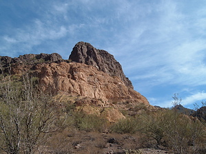
Sudden Wilderness by OhOh7  This Goldfield hike is very interesting with many great vistas. There is a forest service road FS 10 that goes from Apache Junction (Dome Mountain Trailhead) generally north to the Bush Highway where the trailhead is called Blue Point. The route is about 9 miles and there are several ways to traverse the Goldfields through Bulldog Canyon. Some excellent views up several side canyons do beckon for more exploration. Of course, the Superstitions are rugged but do not underestimate the Goldfields. To the east of your general route is Dome Mountain and there is an unmarked trail to the top. It looks quite challenging. This Goldfield hike is very interesting with many great vistas. There is a forest service road FS 10 that goes from Apache Junction (Dome Mountain Trailhead) generally north to the Bush Highway where the trailhead is called Blue Point. The route is about 9 miles and there are several ways to traverse the Goldfields through Bulldog Canyon. Some excellent views up several side canyons do beckon for more exploration. Of course, the Superstitions are rugged but do not underestimate the Goldfields. To the east of your general route is Dome Mountain and there is an unmarked trail to the top. It looks quite challenging.Bulldog Canyon is fairly easy to follow even though there are several offshoots of trails and jeep roads along the route. You can simply try to follow the FS 10 as it winds its way north but you can also follow the creek bed in places and we even did about a half-mile of bushwhacking to get back to the FS 10 when we strayed off course. One positive thing about directions is that it would be hard to get lost. Apache Junction is behind you and the Salt River is north. The canyon is quite well defined through the mountainous area.
Point Rec Area. Of course, you could start at Blue Point and go south. The hike is well worth it as the many views of the Goldfield and the fierce-looking canyons that run off of Bulldog Canyon will amaze you. Above Saguaro Lake you will see Sky island and some extremely cliffs. You see some of them when you drive the Bush highway. FS 10 follows Bulldog Canyon and there are several ups and downs. There are some places where you have the choice to follow the roadbed or a trail or even the creek bed. Just keep headed generally north and you are OK. The gates at either end of FS 10 are locked but as hikers, we don't care. By the looks of the creek bed, any downpour would cause water to really fall down the mountains and the creek would be roaring in short order. Once you reach the north side of the Goldfield mountains and into the Salt River Valley the trail/road somewhat levels out and winds its way to the Bluepoint trailhead. Doing this on a weekday we avoided most of the 4wd rigs and ATVs. A couple came past us and stopped where we chatted a bit. Be sure you know that 4wd and high clearance is quite necessary on this route. There are some places where traction is necessary and high centering is very possible. I always seem to have to mention the trash problem when I hike jeep roads. There was not a lot but a few cans and bottles here and it is very disappointing in such a beautiful area. There was even a bit of waste paper. One startling fact about this hike is that less than a half-hour from Dome Mountain trailhead you are suddenly in total wilderness. No one would guess that the populated area was so close. You could be miles from nowhere. The hike is classified as easy but be aware that it is 9 miles and there are many quite rocky stretches. I have included more pictures than usual because the area is worth a look. Gate Policy: If a gate is closed upon arrival, leave it closed after you go through. If it is open, leave it open. Leaving a closed gate open may put cattle in danger. Closing an open gate may cut them off from water. Please be respectful, leave gates as found. The exception is signage on the gate directing you otherwise. Check out the Official Route and Triplogs. Leave No Trace and +Add a Triplog after your hike to support this local community. | |||||||||||||||||||||||||||||||||||||||||||||||||||||||||||||||||||||||||||||||||||||||||||||||||||||||||||||||||||||||||||||||||||||||||||||||||||||||||||||||||||||||||||||||||||||||||||||