Poison Spider Dinosaur Tracks, Utah :: HikeArizona.COM
Post Hike | Route | Photos | Triplog

 AZ   CA  CO  NM  NV  UT 
A B C D E F G H I J K L M N O P Q R S T U V W X Y Z #
Welcome to Hike Arizona

Register | Login
Welcome to HAZ!
HAZ Forum 
  Poison Spider Dinosaur Tracks, UTPrint: Full / Basic
Jump to Directions
 
Weather Forecast
HAZ reminds you to respect the ruins. Please read the Archaeological Resources Protection Act of 1979 & Ruins Etiquette
Statistics
 Difficulty: 0.5     Route Finding: 2 
 Distance Round Trip 0.2 miles
 Trailhead Elevation 4002 feet
 Elevation Gain 50 feet
 Avg Time Round Trip 0.25 hour
Interest: Off Trail Hiking & Ruins
Course: Loop Hike
Author PageRob
Profile Photo Descriptions: 89
 Routes: 0
 Photos: 2,843
 Trips: 559   (1,120 Miles)
 Age: 28     Gender: Male
 Location: Page, Az.
HAZ Member Photos
 Photos         Date Member
10  01-17-2010  PageRob
9  04-15-2003  PageRob
Photosets Rated Viewed
 
 Canyonlands, UT
Backpack - Possible - Not Popular
Seasons - Early Autumn to Late Spring
GPS Routes
Post one Now!
Expand Map
Street
Terrain
Topo
Culture
 HAZ RidesClick to view photo  Click to view photo
Space
Nearby
Hikes Springs
Direct Air Miles Away to Trailhead
3.1  Corona Arch
6.7  Fins & Things 4X4 Road
11  Double Arch
11  Windows - Arches NP
12  Eye Of the Whale Arch - Arches NP
[ View More! ]       [ View Springs! ]
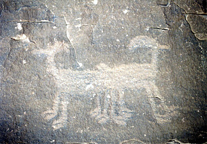
Dinosaur tracks and petroglyphs together!
by
PageRob

The area around Moab, Utah, is one of the most beautiful places on earth. Rolling expanses of red slickrock cover the place, while the La Sal mountains rise to the east, and the Colorado River cuts down through it all, exposing amazing geology and creating astounding side canyons. Millions of people every year come to visit the area, to backpack, hike, mountain-bike, 4x4, raft, or simply see the sights of one of Nature's greatest displays.

Just downriver from Moab, at the foot of Poison Spider mesa and at the bank of the Colorado River lays a unique opportunity to explore the prehistoric past of the area in one easy hike. The Colorado River, cutting downward through the Jurassic-age Entrada Sandstone as it makes for Cataract Canyon, has exposed evidence of some of the area's earliest visitors.

The Entrada Sandstone was deposited during the early-middle Jurassic Period, and was an environment dominated by large, mobile dune fields. Some of the best preserved of these dune fields lay inside nearby Arches National Park, along the park road. In between these dunes, however, were seasonal lakes and some streams. It was hear, in this ancient desert, that life flourished. Ancient crocodiles prowled the streams, while theropod dinosaurs, like Dilophosaurus wetherilli and Coelophysis kayentakatae visited the water holes to drink or hunt. At the southern edge of Poison Spider Mesa, evidence of some of these visitors still exists.

From the Poison Spider Trail parking area, head east-northeast. There is a large pile of boulders heading upslope towards the cliff face. It is here where the majority of the tracks are located. Some previous tourists have chalked over some of the dinosaur tracks, making them easier to see. Please do not continue this practice, as it degrades the footprints over time.

From the dinosaur footprints, head towards the cliff face. You can see a slab of rock that has separated from the main section of cliff. It is here that many petroglyphs from the Fremont culture can be seen, both behind and next to this slab. Some are truly strange, like a giraffe-goat, and two-headed rams. Others are more typical fare, like bighorns and figures. Spend some time exploring here, before returning to your vehicle. Keep an eye out along the way for more dinosaur tracks.

For more fun, on the way back into Moab, make sure to see the "Indian Writing", a large collection of Fremont petroglyphs along the cliff face. The area is signed, but parking is limited, so be careful. There is also the remains of a dwelling that was destroyed during road construction; all that remains are the beam holes up on the cliff face.

There is no water on either portion of this hike. Although the Colorado River is nearby, it is also immediately downstream from the old Atlas Uranium Mill; think twice about drinking it, even with treatment. A better bet is to fill your bottles back in Moab.

- Jan 28 2008 PageRob

Preferred Months  Mar, Apr, Aug & Sep
Wish List
Water/Source:  See Description AboveLogin Required
Preferred Start Time:  Any Cell Phone Signal:  No Sunrise 7:18am Sunset 5:47pm
Road/Vehicle: Paved - Car Okay
Fees/Permit:
None
Login for Mapped Driving Directions

Directions to trail: From Moab, Utah, drive north on US191. After crossing the Colorado River, turn left onto Route 279. Follow 279 south until making a sharp right turn. Look for the Poison Spider Trail parking area on the right hand side. Some of the dinosaur tracks are visible from the road, making it easy to spot. If you're still driving when the road heads north, you've gone too far. For the "Indian Writings" petroglyphs, simply look for the signs saying "Indian Writings" alongside 279.
[Update Directions]     [Update Permit]
WARNING! Hiking and outdoor related sports can be dangerous. Be responsible and prepare for the trip. Study the area you are entering and plan accordingly. Dress for the current and unexpected weather changes. Take plenty of water. Never go alone. Make an itinerary with your plan(s), route(s), destination(s) and expected return time. Give your itinerary to trusted family and/or friends.

Pixel
Trivia III
Map Overview
State Parks under attack (again)
Map Overview
Support

HAZ Forum
 Past
 • REI Events!
 • SALOME Wilderness question
 • Rim berries
 • Dynamic Map Interface
 • Web site layout
 • Dragoon Mountains
 Present
 • Superstition Mountains in a Jeep.
 • Man carried 1,500 feet by northern
 • South Mountain mystery trail
 • Disappearing maps?
 • Overnight backpack near Phoenix in
 • Activity category
 Events  →  View Calendar  →  Add Event
 • 2010-02-14 [ 0, 6, 0 ] Romero Canyon Sunday Feb. 14
 • 2010-02-20 [ 2, 3, 0 ] Homolovi - Last Look
 • 2010-03-06 [ 3, 2, 0 ] Santa Teresas Holdout loop March 6-7,
 • 2010-03-13 [ 6, 4, 0 ] Grand Gulch 2010
 • 2010-04-03 [ 4, 8, 4 ] 2010 Rainbow Bridge Spectacular
 • 2010-07-22 [ 2, 4, 0 ] Tahoe Rim Trail (165 Mi) July 25, 201
About        FAQ        Corrections Corrections       Glossary        Search        © 2010 HAZ