 Route Editor

| Guide | ♦ | 202 Triplogs | 23 Topics |
details | drive | no permit | forecast | route |
stats |
photos | triplogs | topics | location |
| 1.2k | 202 | 23 |
Great! by lorilynnfoster   History HistoryFormerly known as Clear Creek. Now referred to as West Clear Creek to eliminate confusion with the Clear Creek, which flows into the Little Colorado River. Adventure I hiked this trail on May 11, 2002, with the Friends of Arizona Highways hiking club. You can not miss the trailhead once you get down to the end of the road that leads to it. Which, by the way, is not paved and is rough gravel. Cars will be fine. The road dead-ends into a little cul-de-sac and the trailhead is located through a gate in a pole fence. The first mile of the trail remains relatively level, and you are out in the open sun. This first part of this trail is an old jeep trail. After walking a short distance, you will see off to the left, an old farmhouse with lots of prickly pear cactus growing on top of it. Many of us laughed at seeing this odd site. It was here that several members of our hiking group reported seeing a kingsnake.
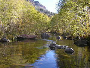
There were three more creek crossings for a total of 4 all together. All of them fit the above description. Nice and shady with patches of sun. In between the creek crossings, the trail turns into a rolling up and down one. Nothing too steep here, and you follow the creek the whole way. The uphill jaunts are just enough to get your heart going slightly, and the downhill ones will let you catch your breath. The scenery between the crossings is beautiful, as well as the creek itself. The land consists of large patches of red rock in contrast to the trees shading the stream. There are many areas where the creek is sunny and stretches that are shaded too. We saw several areas of poison ivy. Please be careful of these three-leaved bright green monsters. Several people saw large fish in the creek, and one person reported seeing javelina and a fox. Now for the highlight of this hike. Once past the 4th crossing of the creek, you will go for about a mile or so. Except you go away from the stream. The trail is mostly in the sun and is hot and is pretty level. Then, the trail veers left, and you can not miss the steep ascent that will take you to the top of the rim, which has an elevation of 5520 feet. It is gradual at first, and then you find yourself panting and wondering just how far this hike will take you. You keep looking up and trying to find the end, but it is nowhere in sight. The trail continues in this fashion for the rest of the way except for one small patch where the trail dipped downward. Several people in our group turned back here because they did not want to begin another journey back upward from going down and because they were tired! Keep climbing and keep climbing on this one. You will know you are at the end of the trail when all of a sudden, it levels out (and you will love this as it is your reward), and you see another sign marking the back entrance to this trail. It says quite clearly, "West Clear Creek." Can't get any clearer than West Clear Creek. You have made it. One of the lucky people to make it to the top ran out of water here. Thank goodness we had enough to help her back. If you make it this far on this trail, you will have now traveled 7.7 miles according to my source. Of course, you have to turn around and go back to get to where you started. Returning takes you downhill from your uphill trek. The dirt consists partly of lava rock, which you will find you have to stumble over. Then after the lava rock, you will encounter loose soil, which will make you slip several times. Be careful here. Not one person in our group did not take a slight tumble onto their behinds. Nothing major, the trail just goes in reverse from here. Some people feel going down is harder than going up. We started this trail and went at a pretty fast clip (constant fast walking) at 9:00 AM. We did not get back to the trailhead until 4:50 PM. One person in the group had GPS. He said he logged 5 miles at the last creek crossing. I know nothing about them and will have to take his word for it. Indeed you could rate the trail as easy or mildly moderate until the strenuous trek up. You will know when it begins. We had over 20 people in our group, and only 6 of them made it the whole way. Gate Policy: If a gate is closed upon arrival, leave it closed after you go through. If it is open, leave it open. Leaving a closed gate open may put cattle in danger. Closing an open gate may cut them off from water. Please be respectful, leave gates as found. The exception is signage on the gate directing you otherwise.
Coconino FS Details This trail provides the only marked and maintained access to the lower reaches of West Clear Creek Canyon Wilderness. From its western terminus at Bull Pen Ranch at the canyon mouth, the trail leads upstream into the deep, narrow gorge which medium-sized West Clear Creek has cut into the southern edge of the Colorado Plateau. The downstream end of the trail attracts large numbers of anglers, picnickers, and other streamside recreators attracted by the clear pools, slickrock water slides, and tree-shaded riparian areas tucked away between red rock canyon walls. From the trail's upper terminus, at Bald Hill, the route drops 1,800 feet down a steep, talus - strewn slope from a high plateau of pinyon-juniper forests to the canyon floor. It then winds its way downstream along a stretch of secluded pools and rocky riffles. Bring your wading shoes on this one, you'll have to cross the stream at least four times. In times of high runoff, this trail can be impassable. In the middle of a hot desert summer you'll appreciate the opportunity to cool off.
Check out the Official Route and Triplogs. Note This is a moderately difficult hike. Leave No Trace and +Add a Triplog after your hike to support this local community. One-Way Notice This hike is listed as One-Way. When hiking several trails on a single "hike", log it with a generic name that describes the hike. Then link the trails traveled, check out the example. | |||||||||||||||||||||||||||||||||||||||||||||||||||||||||||||||||||||||||||||||||||||||||||||||||||||||||||||||||||||||||||||||||||||||||||||||||||||||||||||||||||||||||||||||||||||||||||||||||||||||||||||


