Route Editor

| Guide | ♦ | 15 Triplogs | 0 Topics |
details | drive | no permit | forecast | 🔥 route |
stats |
photos | triplogs | topics | location |
| 235 | 15 | 0 |
Canyons are inherently risky. Flash floods occur without notice on sunny days. Technical skills & surrounding topography knowledge required yet does not eliminate risk.
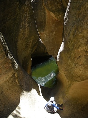
Lookout, you may keep me forever! by nonot   Overview OverviewAn R rated technical canyoneering route into Sycamore canyon containing 1-2 keeper potholes. Warning Canyoneering involves slot canyons, be careful to check the weather before you go and do not if there is any chance of rain. Since this is a technical trip, you will need: HELMET!, harness, and rappelling device. You may need up to 100 ft of rope, 1-7 rap rings, and 20-100 ft of webbing. In spring or fall, wetsuits will be desirable, however, they are not needed in summer (July-September).
DANGER This canyon contains 1-2 keeper potholes, the first of which (when water is low) cannot be done alone. Furthermore, due to the make-up of the other side of the keeper, throw bags are very ineffective, being that they simply slide up the other side of the smooth chute. Since throw bags do not work, the current best recommendation is to travel with a group of 3 or more, using the partner assist technique. The last person may need ascending gear or else two strong buddies to dead haul his bulk (not easy!) when the keeper is low. History Canyon is described in Todd Martin's "Arizona: Technical Canyoneering". The author must have been a novice at his first attempt at this canyon, for he writes that he pulled his rope before realizing exit from the keeper pothole may not have been possible - do NOT repeat this error. The author indicates he may have been the first party to attempt the canyon. Hike From Kelsey TH, walk east and onto FR527A until it crosses a canyon headed northwest. Head down this canyon, which is a bit of a thrash until you reach a junction with Little Lookout Canyon. There are no technical obstacles on the way to the junction. The junction here is rather interesting and the slot forms nearly immediately. Begin descending into Little Lookout until you reach a chute that ends in a large pool. Stop here and drop your gear - heading a bit high on canyon right will let you get to a place that you can look down into the pool exit. If the water does not reach the rim of the pothole, the pothole is in serious keeper conditions. On our visit, the water was 6 ft below the rim. Currently, the exit has some rocks in the area underneath the water that may help to get a stance, but the lip was still well out of reach of a 6 ft man with outstretched arms. Be cautious - if you are unprepared to deal with a keeper turn around now, or else consider bypassing the keeper by rappelling from a tree on canyon right past the obstacle. Otherwise, return to the slot and downclimb the chute into the keeper, the last 5-6 ft of which is too vertically sloped to allow for an exit without a rope. (Note: in wetter conditions, the chute may be too slippery - making rappelling a safer option here). Do not pull the rope until your party has gained a stance out of the keeper! After you enter the pool, you must deal with the keeper (when water is low.) Throw bags proved ineffective due to the slippery slope on the other side. A partner assist currently works best for this obstacle. Immediately on the other side of this obstacle is another semi-keeper - it is definitely a keeper at the exit, but a fault will also allow a scrambling exit out from the left side, making the keeper escape optional. Another chute can be downclimbed at the exit of this keeper (or rappelled in slippery conditions). From here there are numerous challenging downclimbs/rappels. There are many anchors, but we downclimbed all but one. Our one and only rappel in this canyon - a shear rappel of 18 ft into knee-deep water - was an ankle breaker for sure if one thought to foolishly jump. From here is more downclimbing (optional rappelling) until you reach the bottom of Little Lookout as it joins Sycamore Canyon. Shortly before Sycamore canyon itself is the exit trail (Little LO #6) on your left. Proceed 70 ft from the Little LO streambed to the trail junction and head up the trail. A little further along the trail (meaning you missed the place the Little LO #6 trail ascends) is the refreshing Geronimo Springs - a godsend on a hot summer day. Head up the trail, you will come to the intersection of Kelsey Trail - turn left and climb. You will hit Babes Hole Spring - another nice cool-off spot on a hot summer day. Continue climbing to the rim and the TH. Water Sources Babes Hole Spring and Geronimo Spring make the practical water sources for this trip - Kelsey Spring is a swampy area. Camping On the rim - several options near Kelsey TH. Tip Strong, experienced parties can do Little LO and Babes Hole in a single day (7-9 hrs total) Check out the Official Route and Triplogs. Leave No Trace and +Add a Triplog after your canyon trip to support this local community. | |||||||||||||||||||||||||||||||||||||||||||||||||||||||||||||||||||||||||||||||||||||||||||||||||||||||||||||||||