Route Editor

| Guide | ♦ | 30 Triplogs | 0 Topics |
details | drive | no permit | forecast | route |
stats |
photos | triplogs | topics | location |
| 128 | 30 | 0 |
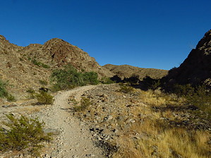
It's steep! by Tealpwraz   There are a few paths that lead up to the mountain. Once there you will go around a gate and start walking up a concrete path. It is a steep walk so be prepared with comfortable shoes, sunscreen, and plenty of water. Once up at the top, you will enjoy views of Yuma and Wellton. Take your time to enjoy a small break, sign the guest book and eat a snack before you head back down. On the walk down, take your time. Remember you will be walking on concrete which can be hard on the joints. There are a few paths that lead up to the mountain. Once there you will go around a gate and start walking up a concrete path. It is a steep walk so be prepared with comfortable shoes, sunscreen, and plenty of water. Once up at the top, you will enjoy views of Yuma and Wellton. Take your time to enjoy a small break, sign the guest book and eat a snack before you head back down. On the walk down, take your time. Remember you will be walking on concrete which can be hard on the joints.For the more adventurous hiker, you might enjoy a trail that goes up the side of the mountain. It's harder to find from the bottom, but once up at the top, you can find it on the left side of the road as you start your descent. As always, watch where you put your hands and where you step. As it gets warmer, the wildlife will be more active. Also, beware of the loose rock under your feet. It's very slippery and some rocks that look like they are sturdy are actually lite and very movable. Again, be careful.
I recommend that you head to Telegraph Pass early in the morning come spring. It starts to heat up early in Yuma. To get to the trailhead, take I8 to Foothill Blvd go north and turn right onto the North Frontage Road. Follow the road until it dead ends. If you have a vehicle that can handle rough, rocky roads you can turn right onto a path that will get you closer to the trailheads. Gate Policy: If a gate is closed upon arrival, leave it closed after you go through. If it is open, leave it open. Leaving a closed gate open may put cattle in danger. Closing an open gate may cut them off from water. Please be respectful, leave gates as found. The exception is signage on the gate directing you otherwise. Check out the Official Route and Triplogs. Leave No Trace and +Add a Triplog after your hike to support this local community. | |||||||||||||||||||||||||||||||||||||||||||||||||||||||||||||||||||||||||||||||