 Route Editor

| Guide | ♦ | 21 Triplogs | 0 Topics |
details | drive | no permit | forecast | 🔥 route |
stats |
photos | triplogs | topics | location |
| 320 | 21 | 0 |
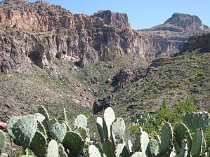
This Is No Waltz In The Park by AZLOT69   Overview OverviewThis trail provides access to Fish Creek at approximately the halfway point between Rogers Canyon and Highway 88 at the Fish Creek bridge. This route offers an escape route from Fish Creek as well as several options for combining other trails and making loops out of them for multi-day adventures. History A hike description in the Superstitions would not be complete without relating its importance as related to the legend of the Lost Dutchman. The Tortilla trailhead is important as one location to access trails to cross the wilderness to the south side of the Superstitions. It was home to the Miller Mines. The drift located by Estee Conaster was documented in her book The Sterling Legend and documented in the HAZ hike entitled, Lost Dutchman Mine Jr. is accessed here. It was also the home of Tortilla Ranch. The last outbuilding of the ranch was eliminated in the 1970s and you will pass by the concrete foundations on your way to the trailhead.
To access the trail you will start on the JF trail #106 at the fence line. In a few hundred feet you will pass a Superstition Wilderness sign. The next fence line is just about fifty feet. Turn left absent a trail and keep the fence on your right. This is an old access road for the Miller Mines but has been reclaimed by nature. Follow the natural flow of the land around obstacles for one-half mile keeping the fence on your right. At the top of a knoll, there is an opening where a gate once stood. It is marked by four nine-foot railroad ties standing in the ground. Pass-thru the gate and head down the ravine for about two hundred feet. Then make a sweeping turn to the east and watch for cairns. It is very important to locate the actual trail at this point and not attempt to bushwhack your way down to Fish Creek. A bushwhack would be brutal. Once you have located the trail you will have to focus on staying with it. It is well cairned but tall grasses hide them. Generally, just scan ahead for the next cairn without getting in too big a hurry. If you go more than one hundred feet without seeing a cairn you have lost the trail and I suggest backtracking to reestablish it. The trail is faint. If you lose it it's very hard to relocate. The trail continues to bear left and eventually follows the contour of the sheer cliffs ahead. The views of Fish Creek Canyon to the north and the east are awesome and continue to get better. As the descent gets steeper you may hear the flow of water in the creek. Experience tells me that if the water is flowing at this point in the creek you better be prepared for some water recreation if you continue either direction in Fish Creek. Don't underestimate the time it will take you to continue from this point without being prepared to spend the night. Travel is slow and full of obstacles in either direction. For a comfortable day trip return the way you came. Use and knowledge of a GPS and the associated track will be a huge asset on this hike. Keep in mind if you lack a 4 x 4 and had to start at the highway 88 parking area this trip is 6.4 miles one way. Gate Policy: If a gate is closed upon arrival, leave it closed after you go through. If it is open, leave it open. Leaving a closed gate open may put cattle in danger. Closing an open gate may cut them off from water. Please be respectful, leave gates as found. The exception is signage on the gate directing you otherwise. Check out the Official Route and Triplogs. Leave No Trace and +Add a Triplog after your hike to support this local community. One-Way Notice This hike is listed as One-Way. When hiking several trails on a single "hike", log it with a generic name that describes the hike. Then link the trails traveled, check out the example. | ||||||||||||||||||||||||||||||||||||||||||||||||||||||||||||||||||||||||||||||||||||||||||||||||||||||||||||||||||||||||||||||||||||||||||||||||||||||||||||||||||||||||||||||||||||||||||||||||||||||||||


