Note
This once desolate patch of Sonoran desert is now a neighborhood. View the Official Route to the right.
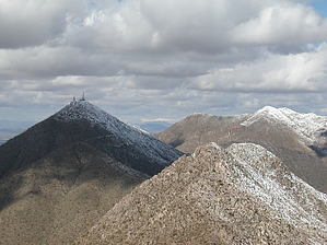
From the trailhead, hike along the main road to the right through private property to the county park boundary, where you must pay a fee of $1 per person. $2 as of 2022-02-28. Follow the trail to the Dixie mine, clearly marked. This part of the trail is relatively flat but affords fantastic views of Four Peaks and the Superstitions along its entire length. If you don't have time for the summit hike, the hike to the mine and back is lovely, easy, and enjoyable. This section of the trail would provide an excellent introduction to the Sonoran landscape for relatives from out of town.
Once you reach the mine, follow the obvious road to the left and straight up the mountain. The last two miles of this hike is extremely steep, as the road builders decided to charge directly up the mountain rather than bother with those wimpy switch-backs. This is about as steep a trail as I have ever been on...and I felt the burn!
Views from the top of Thompson Peak are of the entire Phoenix metro area (many golf courses down below in Scottsdale), south to the Catalinas, east to the Superstitions, and north to the Mazatzals. The best view is, unfortunately, of the cell-phone towers and related infrastructure that diminish the peak experience. The least Verizon could do is provide a picnic table or something. Remember to bring a walking stick because the hike back down the steep trail is hard on the knees. It is so steep that if you tumbled, you'd probably keep rolling until you ended up in someone's front yard in Fountain Hills.
WARNING! Hiking and outdoor related sports can be dangerous. Be responsible and prepare for the trip. Study the area you are entering and plan accordingly. Dress for the current and unexpected weather changes. Take plenty of water. Never go alone. Make an itinerary with your plan(s), route(s), destination(s) and expected return time. Give your itinerary to trusted family and/or friends.
Permit $$
None
Directions
Road
Paved - Car Okay
To hike Take Hwy 87-the Beeline- to Shea. Turn towards Fountain Hills. Go north on Saguaro to Palisades, then west to Golden Eagle. The Fountain Hills High School is on the corner of Golden Eagle and Palisades Blvds.
2010-04-29 te-wa writes: From the high school intersection, go north about 3 miles to the terminus of Golden Eagle. There is a guard shack that prevents further travel and a decent-sized lot on the left for trailhead parking. Follow the signs as they direct you to the Dixie Mine and Thompson Peak trails.
 Route Editor

 Note
Note