 Route Editor

| Guide | ♦ | 134 Triplogs | 2 Topics |
details | drive | no permit | forecast | 🔥 route |
stats |
photos | triplogs | topics | location |
| 1.2k | 134 | 2 |
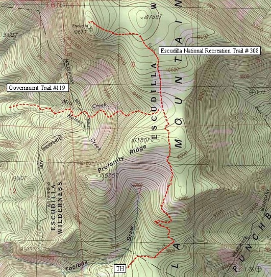
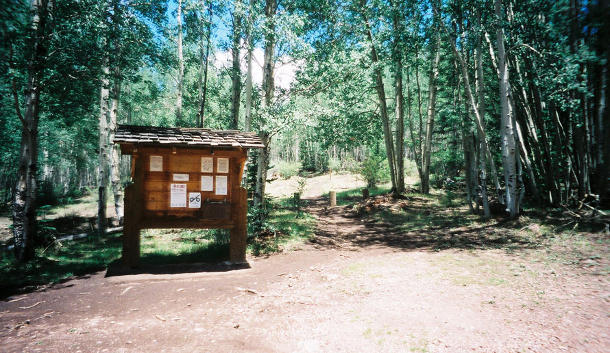
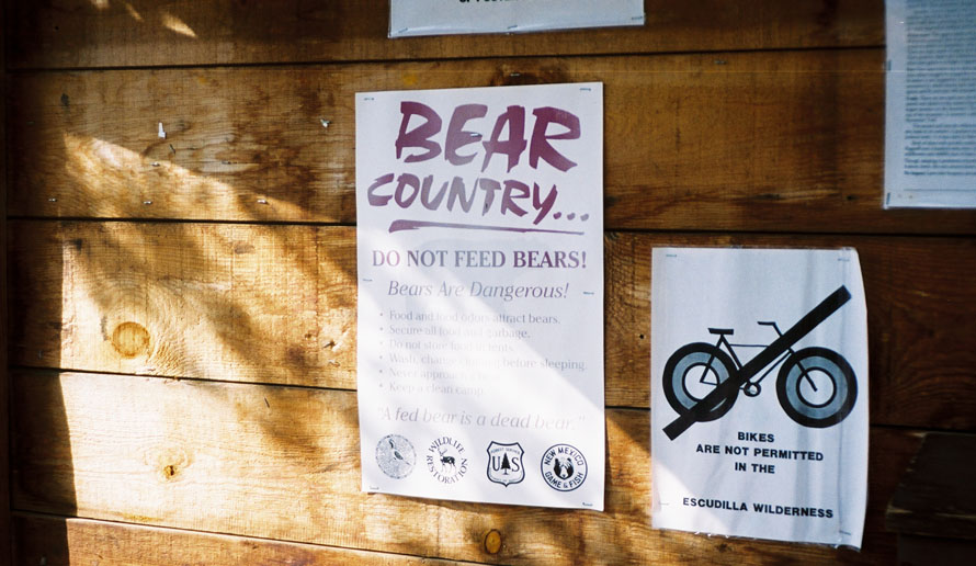
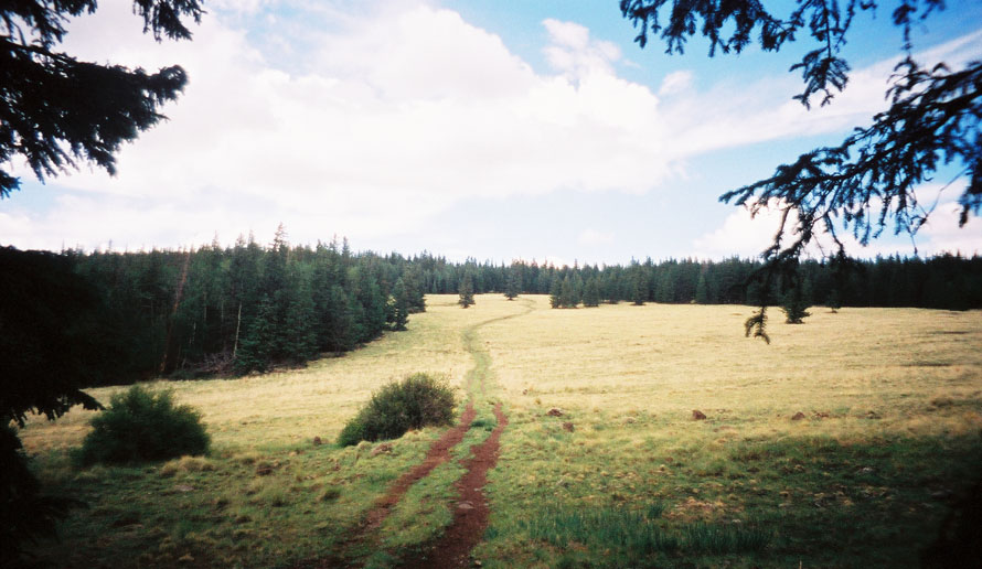
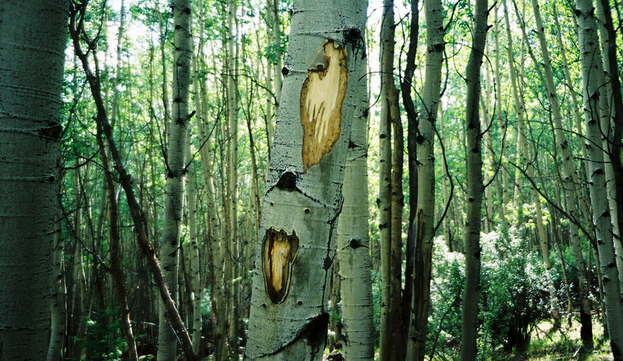
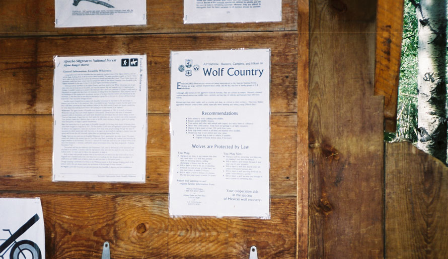
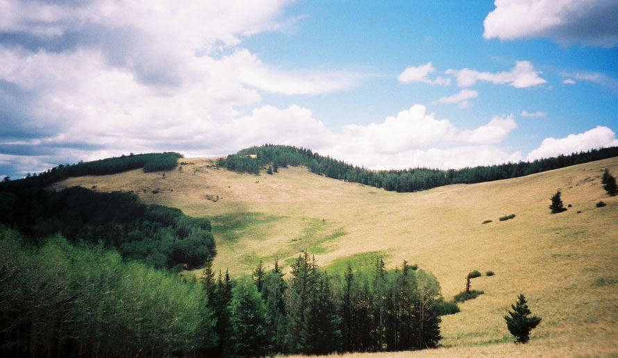
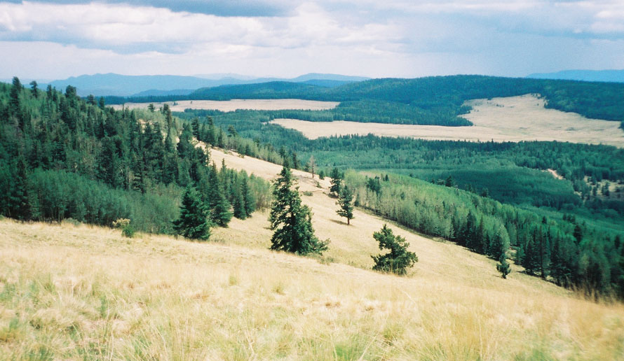
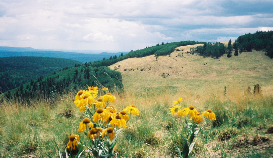
Alpine Beauty! by Randy  Escudilla Peak is Arizona's third-highest mountain, at 10,912 feet above sea level. You can get another 40 feet or so by climbing the fire watchtower at the summit. In Spanish, Escudilla means "Wide Bowl." When you hike up the trail to the summit or even drive up the approach road, the reason for the name is self-evident. The mountain features a wide bowl-like area with several open meadows. To hikers, Escudilla means, "This is so great I don't want to go back to the office." Escudilla Peak is Arizona's third-highest mountain, at 10,912 feet above sea level. You can get another 40 feet or so by climbing the fire watchtower at the summit. In Spanish, Escudilla means "Wide Bowl." When you hike up the trail to the summit or even drive up the approach road, the reason for the name is self-evident. The mountain features a wide bowl-like area with several open meadows. To hikers, Escudilla means, "This is so great I don't want to go back to the office." The trailhead is not a good spot to camp. Several more suitable places exist further down the Terry Flats road. The trailhead has an information sign, a registration log and several warnings about bear safety. The area has a significant black bear population, so all the appropriate safety measures should be addressed. These bears, like those in the Chiricahuas to the south, may not be multi-lingual, so if they do not respond to, "Holy S**t, a Bear," try "Hola, Oso Negro!" instead. "Please don't eat me, I'm not kosher" probably will not help as these bears are rarely Jewish. So, avoid open foods such as cheese, bread, and those little Vienna Sausages on the trail, and bear bag religiously. This is not a good place to bring those yummy little tins of smoked oysters in oil, especially if you don't have a hot fire to incinerate the odors. The trail starts at 9600 feet and climbs 1312 feet to the 10,912-foot summit in a little over three miles. The trail condition is pretty good; it used to be a 4x4 road before the area was designated wilderness. It still shows signs of being a double track in places, but it has reverted enough that it feels like a trail and not one of those annoying roads that we sometimes have to include on our hikes. The route seems a tad longer than the three miles cited by the Forest Service. It is possible that they scaled the distance off the map rather than using a wheel or a pedometer. The area burned about fifty years ago, and as is usual at such altitudes, much of the burn area is now dominated by a climax Aspen forest. This hike (along with portions of the Hart Prairie road northwest of Flagstaff) is one of the most dramatic fall color places in the state. The rest of the vegetation is primarily fir and Englemann Spruce, with a smattering of oak at the lower levels of the trail. If you look carefully, you can spot bear scratch marks on Aspen trunks in places where game trails cross the route. The last Grizzly Bear in Arizona was killed on Escudilla in 1936. It is a shame that Oso Plateado, the southern or Mexican Grizz, is no longer with us. (Edward Abbey says singular is Griz, the plural is Grizz. He would have known.) His existence in the Sierra Madre south of the border is in some doubt too, due to the use of poisons there. At least the wolf is back. Some of the reintroduced Lobo is in the Escudilla area from time to time. Just under a mile and a half up the trail, the route crosses Tool Box Meadow, a lovely open clearing. Here, you can start to appreciate the views of the surrounding area. This is a good place to spot elk early in the day or at dusk. At the two-mile point, the Government Trail crosses our route. This junction is signed. Beyond this point, which is at about 10,500, the modest climb levels a bit and skirts another clearing before approaching the summit. On this trip, we turned back at this point due to an approaching storm. An old iron tower sits on the peak. Climbing it gives a view above the trees. On a clear day, one can see the San Francisco Peaks off to the northwest, Mt. Graham to the southeast, and the Mogollon Mountains and Black Range of the Gila Wilderness Area to the southeast, as well as the Blue Primitive Area directly south. If one had to spend the next twenty years hiking in a 75-mile radius around Escudilla, it would not be a bad thing. You are less than ten miles from the New Mexico line here. While on the tower, see if you can spot two peaks that look like rabbit ears. They mark the location of the Lost Adams Diggings, the richest gold finds ever in North America. The diggings were reportedly somewhere in the Malapai lava flows to the north. Before being attacked by resident Apaches under Chief Nana, the miners dug out nuggets larger than robin's eggs. If you find it, please post the location on HAZ; we can all retire. For an interesting historical perspective on the area, two books are recommended: Apache Gold and Yacqui Silver by J. Frank Dobie; and Black Range Tales, by James "Uncle Jimmie" McKenna. McKenna's story of the Lost Adams Diggings was-very loosely- used as the basis for the movie McKenna's Gold, which was, for some reason, filmed in Monument Valley and Canyon De Chelly rather than this area. When you have to leave (sigh) return by the same route. The return trip is somewhat quicker. None of the route is dramatically steep, which makes for a pleasant family outing. This is an ideal trail for those not up to a Mt. Humphries style challenge but still, want a taste of alpine Arizona.
Apache - Sitgreaves FS Details This 3 mile walk to the top of Arizona's third highest mountain is such an outstanding trail that it has been given recognition by Congress as a National Recreational Trail. The scenery is magnificent, the surroundings are picturesque and the walking is comparatively easy, considering the heights to which you are headed. More of a pleasant stroll than a strenuous climb, this is the trail that the Alpine District recommends to outings groups to when they ask the Forest Service to point out a good day hike. The climb up Escudilla starts out through an area that was burned by a huge wildfire in 1951. Evidence of the impact of that fire is apparent along the trail in the form of large Douglas fir stumps left from trees that were killed by the blaze. Those blackened snags were later cut in an effort to salvage what wood could be recovered in the aftermath of the fire. The stumps now are being naturally recycled into the forest ecosystem in the shade of a thick growth of aspens which has sprung up in the aftermath of the fire. This area is such an extensive example of natural reclamation that it has been designated a Research Natural Area. After leaving the first aspen grove, the trail passes through stands of spruce, fir, and more aspen alternating with large open meadows as it continues the climb to the top. Along that climb, various overlooks provide awe-inspiring views of the countryside over which this sky island towers. The first views to the south and west occur about a mile from the trailhead at the top of Tool Box Draw. They're almost as good as those at the top of the mountain. If it's views you're after, you don't even have to walk all the way to the top. When (and if) you do get to the summit, there's a Forest Service fire tower which offers an even higher vantage point. From the tower (on a clear day) you can see the San Francisco Peaks near Flagstaff as well as the high peaks and deep canyons of the Blue Primitive Area. The Gila Wilderness, Mt. Graham and the Pinalenos are usually visible to the south. 0.0 Trailhead parking area. 0.1 Enter Escudilla Mountain Wilderness. 0.7 Aspen trees have been cut to increase browse for deer (Wildlife Habitat Improvement Project). 1.3 Tool Box Meadow-panoramic views. 1.9 Junction Government Trail. 2.8 Spur trail to left, continue right on old roadbed. 2.9 Spur trail on right leads to Bead Springs Meadow (no camping). 3.0 Escudilla Lookout
Check out the Official Route and Triplogs. Leave No Trace and +Add a Triplog after your hike to support this local community. | ||||||||||||||||||||||||||||||||||||||||||||||||||||||||||||||||||||||||||||||||||||||||||||||||||||||||||||||||||||||||||


