Route Editor

| Guide | ♦ | 136 Triplogs | 4 Topics |
details | drive | permit | forecast | route |
stats |
photos | triplogs | topics | location |
| 485 | 136 | 4 |
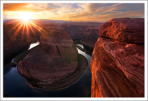
Don't horse around here! by PaleoRob  2020 2020Stats now reflect the new Official Route. Preserving the guide below for history. Overview Horseshoe Bend is one of the easiest hikes in the Page/lower Lake Powell area. Despite this, it has one of the most spectacular scenes in all of the southwest as its destination; the 1200 foot drop to the Colorado River in the middle of the last free-flowing stretch of Glen Canyon.
The hike starts with a brief heart-rate increasing climb up the side of a sand dune to a low mesa top. As you head west across the top of the mesa, you can see the rim of Glen Canyon below you starting to emerge. Beyond that are the Death Pockets and the Vermilion Cliffs. To the north is the town of Page and beyond that Smokey Mountain. Due east is P Hill, where ages of Pageites have painted their town's first initial on the sandstone cliff. To the south lays the Navajo Nation and US 89 winds its way up through a series of roadcuts the locals call The Little Cut. Take a look around because this is the highest point on the hike, and as you continue towards Horseshoe Bend, you'll be looking down at most of the scenery. After crossing the mesa, the trail begins down the mesa's west side via another sand dune. There are some minor switchbacks near the base of the dune. Then you're down on the bedrock. The trail disappears at this point, and there are no cairns, but your route should be generally obvious; keep heading west. A rise in the bedrock marks the rim, so you can step up and then look out at the scene below you. The Colorado River, released from Glen Canyon Dam some 9 miles upstream, flows cold and clear-green. Fishers can often be seen plying the Colorado River's waters in this stretch, as this cold water forms excellent trout habitat. Condors occasionally fly overhead in the spring, looking for anything that might have died recently. Looking into the bend, on the right canyon wall, down near the water where the river first comes into view, you can see the Horseshoe Bend Petroglyph Panel. Often during the summer, a park ranger will have a spotting scope trained on the images to help you locate them. The canyon you see entering just downstream of the panel is Nine Mile Draw, which can (possibly) be descended to the river only with technical rock climbing gear. Be careful near the edge, as high winds can sometimes boil up out of the canyon, making this place dangerous. Once you have seen all you wanted to, return to the trailhead via the same trail. If it seems like you're climbing further up than when you left the trailhead, you are. The rim is almost a hundred feet lower than the trailhead itself. This hike is totally exposed with no water or shade. Bring what you need and consider starting early or late if you are doing this hike during the summer. NPS Details From the top of the short hill, it is 0.4 mile (0.65 km) to the viewpoint. The wide, sandy trail winds past sage, blackbrush, yucca, and other desert plants. There is no shade. Take water with you. The view of Horseshoe Bend from the rim of the canyon is extraordinary. (You'll need a wide-angle lens to get the entire scene in your picture!) Below you, the Colorado River makes a wide sweep around a sandstone escarpment. Long ago, as the river meandered southward, it always chose the most downward slope. This downward journey did not always occur in a straight line, and sometimes the river made wide circles around higher spines of rock. Here at Horseshoe Bend, the Colorado River did just that, and as the river cut down through the layers of sandstone, it created a horseshoe-shaped bend in the canyon. Conceivably, at some time far in the future, the river could erode through the narrow neck of rock, creating a natural bridge and abandoning the horseshoe- shaped channel around the rock. Please note: There are no guard rails at the viewpoint. Watch your footing, and keep track of your children! Check out the Official Route and Triplogs. Leave No Trace and +Add a Triplog after your hike to support this local community. | |||||||||||||||||||||||||||||||||||||||||||||||||||||||||||||||||||||||||||||||||||||||||||||||||||||||||||||||||||||||||||||||||||||||||||||||||||||||||||||||||||||||||||||||