The Sixshooter Canyon Trail is challenging, beautiful, and has some fascinating history! Some historical accounts attribute the name "Six-Shooter Canyon" to the fact that the workers at the sawmill (which you will encounter at about 4.5 miles) all seemed to be packing Six-Shooters. This was an active mine in the 1880s, along with a sawmill and cabin in this area. The mine eventually flooded with water. The forests were thinned out considerably by over-harvesting... leaving skeletal remains of the mill and cabin and mineshaft... today; they add interest to our hikes!
The trail in the Pinal Mountains near Globe works its way through different biomes as it rises some 3000 feet in 6 miles. This is a "sky island" as the mountain rises abruptly from the desert floor.
The 1st mile of the trail is along a fairly exposed route primarily through manzanita shrubs until it descends into the Sixshooter Creek drainage. Starting at about 0.4 miles, a series of switchbacks take you down to the creek that you cross many times on the trail. Here you are, hiking in a riparian community with Arizona Sycamore, Fremont Cottonwood, and Hackberry lining the creek sides. Taking the right fork at about 0.8 miles, you quickly climb out of the creek bed, heading back into the chaparral as the trail makes its way up the mountain. You are treated to some panoramic vistas of the Miami/Globe are along this part of the trail.
By mile 2, you have tree cover from the canopies of Gambel Oaks. As you continue to hike, you encounter an interesting variation depending on the side of the canyon you are hiking on - high desert vegetation of juniper, agaves, pinyon, and prickly pear among the rocky canyon walls to Gambel Oaks and mixed pine cover. You begin to see Quaking Aspen and Arizona Walnuts in moist-microclimate areas near the creek. The trail widens as it heads away from the canyon and enters a pine-oak forest at about 4 miles. At mile 4.5, the trail joins an old road and is now in a forest with hardwoods, mixed conifers, Bigtooth Maple, and velvet Ash. The trail sharply descends and levels off until it reaches the abandoned mineshaft (left side) and ruins of the cabin. Just after this, the trail forks, the right fork is Telephone Trail #192 that continues over to Icehouse Canyon Trail #198. Take the left fork and continue to climb through mixed conifers and aspen for about 0.5 mile to another fork, where you will turn right to the end of the trail at Ferndell Spring. The trail ends about a quarter-mile past Ferndell Spring at its junction with the Middle Trail that heads to the top of Pinal Mountain. Head back out the way you came up -- Its all downhill, and watch your step. Hiking poles do help on this trail.
When hiking several trails on a single "hike", log it with a generic name that describes the hike. Then link the trails traveled, check out the example.
WARNING! Hiking and outdoor related sports can be dangerous. Be responsible and prepare for the trip. Study the area you are entering and plan accordingly. Dress for the current and unexpected weather changes. Take plenty of water. Never go alone. Make an itinerary with your plan(s), route(s), destination(s) and expected return time. Give your itinerary to trusted family and/or friends.
Permit $$
no fees or permits reported
if incorrect tell us about it
Directions
Road
FR / Dirt Road / Gravel - Car Okay
To hike To access the trail, drive to Globe and turn right (south) on Hill St just past mile marker 251. There is a sign for Pinal Mountain Recreation Area. Follow the Recreation area signs. About 2.5 miles from town, Forest Service Road #112 (Icehouse Canyon Rd) intersects with Forest Service Road #222 (Sixshooter Canyon Road). From there, bear right on #112 (Icehouse Canyon Rd). Proceed about 5 miles to a picnic area on the left side of the road. The last mile is unpaved, but graded and easily traveled by car.
2007-10-20 nonot writes: Take 60 E to Globe. Turn right (south) on Hill St past mile marker 251. Note: There is no street sign to tell you this is Hill St, it's the one immediately (100 ft) past mile marker 251, there is a traffic light here.
After turning right on Hill Street, you will go about 300 yards and it will dump you onto another nameless road. Turn right here, go about 200 feet, then turn left. You may spot the Pinal Mountain Recreation Area sign if you are lucky. You will be on a hillbilly bridge. Immediately on the other side, go left and another immediate left at the Y.
You will be on Sixshooter Canyon Road #222, but you won't know it because there are almost no street signs. After about 2 miles, look on the right for a road coming in, there will be signs for Pinal Mountain Recreation, but they will be hidden by the trees, so you may not see it in time. Take a right on this road and go south, you are on Icehouse Canyon Road #112, but you probably didn't see the sign for it, either. After about 3 miles, you will be at a stop sign with Kellner Cyn Rd, keep going straight. The intersection with other forest roads further on are gated off. The road will turn to dirt. After about 1 mile, you will see a sign for CCC Trailhead #2, or something similar, pointing left. Don't bother looking for picnic tables, you can't see them from the road. At the intersection, go left (you may see a sign #112a in the distance) take this about 0.3 miles to the trailhead. Right before you park you will see Telephone Trail #192 going off west. Where you do park, go through the huge barred-off area north to get to the start of SixShooter Trail 197.
 Route Editor


 The Sixshooter Canyon Trail is challenging, beautiful, and has some fascinating history! Some historical accounts attribute the name "Six-Shooter Canyon" to the fact that the workers at the sawmill (which you will encounter at about 4.5 miles) all seemed to be packing Six-Shooters. This was an active mine in the 1880s, along with a sawmill and cabin in this area. The mine eventually flooded with water. The forests were thinned out considerably by over-harvesting... leaving skeletal remains of the mill and cabin and mineshaft... today; they add interest to our hikes!
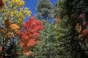


