Route Editor

| Guide | ♦ | 150 Triplogs | 1 Topic |
details | drive | permit | forecast | 🔥 route |
stats |
photos | triplogs | topic | location |
| 1.3k | 150 | 1 |
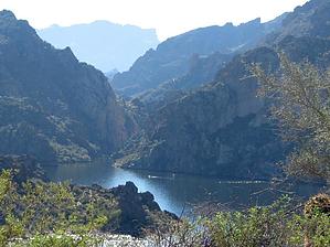
Trash and beauty by OhOh7  History by Teva Joe History by Teva JoeDr Jones did surgery on his dining room table... the butcher was supposedly a friend of our favorite Dutchman. The recreation area opened in 1960. By late '62 after 150k visitors it closed two months for renovations due to being so busy. In '64, three Saguaros were axed down across a road in an attempt to cause an accident. Hike This is a lakeside hike on the east side of Saguaro Lake and is an excellent hike to take out of town guests who think Arizona is all desert. Dan and I were abaolutely stunned and disgusted at the trash and garbage we saw along the trail. We can not believe there are idiots who simply drag their trash along the trail with beer bottles and cans and have no respect at all for nature.
A nice variation that will add a mile or so and some climbing can be done when you come to the first u turn around a lake arm. The main trail goes to the right around the end of the arm but another faint trail goes to the left up a hill. You can climb to the top where you can look down on the parking lot and see the Four Peaks clearly. Except for the horrible trash we saw, this is a wonderful trail that has trees, reeds, water, desert plants and beautiful flowering trees. Your friends from other states will not believe we are in the center of the Arizona desert (even though the lake is man made by Stewart Dam) Gate Policy: If a gate is closed upon arrival, leave it closed after you go through. If it is open, leave it open. Leaving a closed gate open may put cattle in danger. Closing an open gate may cut them off from water. Please be respectful, leave gates as found. The exception is signage on the gate directing you otherwise. Check out the Official Route and Triplogs. Leave No Trace and +Add a Triplog after your hike to support this local community. | ||||||||||||||||||||||||||||||||||||||||||||||||||||||||||||||||||||||||||||||||||||||||||||||||||||||||||||||||||||||||||||||||||||||||||||||||||||||||||||||||||||||||||||||||||||||||||||||||||||