username
X
password
register
for free!
help
  
   🔥

Ajax Peak 4356 - Mineral Mountains, AZ

Guide 3 Triplogs  1 Topic
  5 of 5  
Fav
Wish
0
details
drive
permit
forecast
🔥
route  
stats
photos
triplogs
topic
location
70 3 1
Statistics
tap row or icons for details
Difficulty 3.5 of 5
Route Finding 2 of 5
Distance Lasso-Loop 1.67 miles
Trailhead Elevation 3,696 feet
Elevation Gain 679 feet
Accumulated Gain 922 feet
Avg Time Round Trip 2 hours
Kokopelli Seeds 6.28
 Interest Off-Trail Hiking & Peak
 Backpack Possible & Connecting
unreported if dogs are allowed
editedit > ops > dogs to adjust
feature photo
Photos Viewed All MineFollowing
Will recalculate on button tap!
20  2012-12-12 CannondaleKid
50  2012-07-09 CannondaleKid
Author
author avatar Guides 44
Routes 162
Photos 24,766
Trips 2,411 map ( 18,558 miles )
Age 75 Male Gender
Location Mesa, AZ
Associated Areas
list map done
Globe Region
Historical Weather
Trailhead Forecast
Radar Map
Expand Map
Preferred Nov, Mar, Apr, Feb → 8 AM
Seasons   Winter to Spring
Sun  6:01am - 6:45pm
Official Route & 1 Rt
 
0 Alternative
 
Historic Fire Perimeteracres
🔥 2021 Telegraph Fire266.7 mi**


remove free decal offer
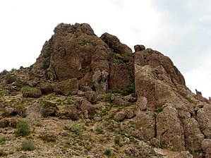
Not for the exposure challenged!
by CannondaleKid

  
Overview
Ajax Benchmark is located in the Mineral Mountain Quadrangle, which is just south of the US 60 between Florence Junction and Superior. Typical of peaks in the Mineral Mountain Quad, the drive to the trailhead is every bit as much of a challenge as the actual climb, and Ajax Benchmark is no different. Depending on the capability of your vehicle and how far you are willing to drive it, this hike can be as short as 1.5 miles to more than 8 miles round-trip. Elevation gain and time will be as much or as little as you feel comfortable with.


Hike
From the trailhead probably the simplest route is to head straight east directly toward the mountain, dropping down to the saddle just below the TH then following the slope up and just to the north (left) of Ajax Benchmark. Although the summit approach itself is on the SSW face, I was not aware of it so I continued clockwise around the peak until locating it, about 3/4 the way around. Although I did not attempt it on the return, I'm not so sure circling 1/4 the way counter-clockwise would be any easier as there appears to be much more exposure in that direction. I ultimately followed the ridge straight south until connecting with the old no-longer-in-use section of the Great Enchantment Trail which I followed back to the saddle below the trailhead then back up to the trailhead. So you can either do this as an out-and-back or make a loop, wandering where ever your curiosity takes you.

2012-07-10 CannondaleKid


    Check out the Official Route and Triplogs.
    Leave No Trace and +Add a Triplog after your hike to support this local community.
    WARNING! Hiking and outdoor related sports can be dangerous. Be responsible and prepare for the trip. Study the area you are entering and plan accordingly. Dress for the current and unexpected weather changes. Take plenty of water. Never go alone. Make an itinerary with your plan(s), route(s), destination(s) and expected return time. Give your itinerary to trusted family and/or friends.

     Permit $$
    AZ State Recreational Land Permits
    For hiking, driving & sightseeing purposes, you seek a recreational permit.
    Under "Recreational Land Use" in the link above.
    2022 - $15.00 individual
    2022 - $20.00 family limited to two adults and children under the age of 18
    Plus $1 processing fee
    The permitting process is quick, you will be emailed your permit instantly.

    Land Parcel Map


     Directions
    or
     Road
    Strictly 4x4

    To hike
    Take the US 60 east toward Globe, continuing about 3.5 miles east of Florence Junction to the turn-off onto the dirt North Mineral Mountain Road. You will be crossing Arizona Trust Land so be sure to have secured your annual permit. Heading south from the US 60 you will continue on N Mineral Mtn Rd to the junction with Ajax Mine Trail (road) at about 7 miles. (Note, there will be other junctions prior to this point so I'd recommend you download the GPS route for the drive.) Continue east on Ajax Mine Trail for about 5.2 miles to N33.20716 W111.15008. This is the junction where Ajax Mine Trail, Telegraph Canyon Road (SW from Superior), and Forest Road 976 meet at N33.20699 W111.15022. Follow FR 976 3.2 miles to the trailhead, which is within .1 mile of the AZT #17 TH (The end of #16 and the start of #17). I'd suggest following the GPS route I posted of the drive from the US60 to the TH. [ALTERNATE Eastern Approach] NOTE: I recommend this approach ONLY if you are coming from Superior or points east because you will save 5.5 miles off-road. However, from the west, you'll add 11 miles on the US60 and thus add 5+ miles to the total drive, plus the last 4 miles to FR 976 on Telegraph Canyon Road is MUCH rougher! To follow this approach, turn south on Mary Street from the US60 (west end of Superior) at N33.28540 W111.11757. Follow Mary St to Golf Course Rd, turning right immediately after the Fire Station. About two miles out (shortly after it becomes a dirt road) turn right onto Forest Road 4, which is Telegraph Canyon road. Follow FR4 to FR976 at N33.20699 W111.15022. Follow FR 976 3.2 miles to the trailhead.
    page created by CannondaleKid on Jul 10 2012 8:42 am
     90+° 8am - 6pm kills
    helpcorrectionissue

    end of page marker