Route Editor

| Guide | ♦ | 12 Triplogs | 1 Topic |
details | drive | no permit | forecast | 🔥 route |
stats |
photos | triplogs | topic | location |
| 147 | 12 | 1 |
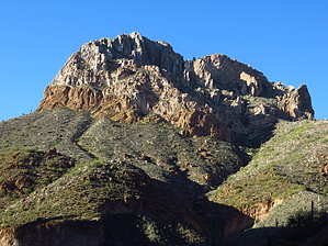
Terrible Beauty or Awesome Beast? by CannondaleKid   Battle Axe Butte is located in the Teapot Mountain Quadrangle in Pinal County. Along with a rise of 951' from the surrounding terrain, it's official elevation is 3,531', which ranks it at #4592 for the state of Arizona. The summit coords are: 33.1530?N, 111.0876?W Battle Axe Butte is located in the Teapot Mountain Quadrangle in Pinal County. Along with a rise of 951' from the surrounding terrain, it's official elevation is 3,531', which ranks it at #4592 for the state of Arizona. The summit coords are: 33.1530?N, 111.0876?WTerrible Beauty, or Awesome Beast? Which is it?
Awesome Beast: Along with that 'terrible' beauty comes the breathtaking, formidable, impressive, stunning, mesmerizing, and magnificent rock that is indeed AWESOME in its 'beast' ly-ness. Hmmm? Did I use enough adjectives to describe this Beauty-and-Beast? After spending a very intimate morning scaling Battle Axe, I don't doubt you'd come up with even more descriptive words for this aptly-named butte. Ok, so what's it like? The round-trip is only 1.66 miles, but it comes over 1,500 of accumulated elevation gain, so it gets the juices flowing. The trailhead is a small pullout barely feet off of Battle Axe Road at Battle Axe's base. To begin with, pick a cow-path heading up and follow it until you lose track of it, by which time you'll probably be able to discern your route of choice. I found the easiest thing to do was stick along the ridge as it winds its way up to the climb's real meat (rocky section). I was lucky enough to scare up a deer that bounded up the slope, leaving hoof-prints to guide me along a nice game trail for a short distance. The first part of the climb is easy enough with enough ground vegetation for reasonably stable footing. As you hit the beginning of the rocky area at the half-mile point, there will be a transition from hiking into more of a climbing mode. A few zig-zags will bring you up to the next section. Although steeper than the first half-mile, it still has a reasonably stable footing. For the next 0.2 miles, you will traverse to the left while climbing until you reach the saddle (albeit a tiny one) where you have a beautiful view south over the Gila River valley. But wait, you're not done yet. The real climb is just about to begin. The last 400' to the southeast comes along with 120' AEG, so this is where you are genuinely in 'climb' mode, which for me was death-defyingly, WAY out of my comfort-zone scary climb mode. And as usual, I took little comfort in wondering 'how am I going to get back down?' even as I continued up. Here is where you seek out every little nook-and-cranny that will provide purchase for the next step, even if it only provides 6" of movement. Sometimes this is wedging your boot into a crevice. Sometimes it's solid rock. Other times the rock breaks loose (usually after it was stable for your hand, but not when you put your foot on it), and you have a singular heart-in-throat moment. Finally, at times you're desperate enough to grab onto the smallest (and sometimes dead) piece of vegetation that provides just enough grip (confidence?) to climb another foot. Finally, when you pop up and find you have reached the summit... whoa! Wait a minute! Hold your horses! It's just a false summit, and you STILL have 160 feet still to go. At least it's horizontal instead of vertical, so what's so bad about that? Well, at one point along that 160 feet, you have a 200' drop on one side, possibly even more on the other, and you only have a pointed rock to climb over, well let me tell you, that was too much for this old geezer with a healthy (unhealthy?) fear of falling. But for the adrenaline junkies in the bunch, I say go for it. You will feel the rush as you bathe in the beauty of this scary beast. Check out the Official Route and Triplogs. Note This is a moderately difficult hike. Leave No Trace and +Add a Triplog after your hike to support this local community. | |||||||||||||||||||||||||||||||||||||||||||||||||||||||||||||||||||||||||||||||||||||||||||