Route Editor

| Guide | ♦ | 4 Triplogs | 1 Topic |
details | drive | permit | forecast | 🔥 route |
stats |
photos | triplogs | topic | location |
| 132 | 4 | 1 |
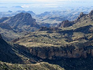
Piece-of-Cake or Tough-as-Nails by CannondaleKid   Peak 4202 is located in the Mineral Mountain Quadrangle in Pinal County. With a rise of 382' from the surrounding terrain and its 4202' elevation, it ranks #4035 for the state of Arizona. The summit coords are: 33.1700 -111.1323. It is the second-tallest peak in the Mineral Mountain Quadrangle, a mere 154' lower than Ajax Benchmark, less than 0.7 miles to the north. Peak 4202 is located in the Mineral Mountain Quadrangle in Pinal County. With a rise of 382' from the surrounding terrain and its 4202' elevation, it ranks #4035 for the state of Arizona. The summit coords are: 33.1700 -111.1323. It is the second-tallest peak in the Mineral Mountain Quadrangle, a mere 154' lower than Ajax Benchmark, less than 0.7 miles to the north.One feature about Peak 4202 that has stuck with me is that it provides the morning shadow over the last few miles of Passage #16 of the Arizona Trail, with the summit itself within 0.75 miles of the Arizona Trail Passage #17 trailhead. But rather than stopping at the AZT17 TH (which is barely more than a barbed-wire gate) just continue up the hill a few hundred yards and there is a nice flat camping/parking area, complete with its own tree. But nice as it is, it is just as remote as the AZT#17 TH... the last few miles of 'road' are only for an ATV or a very capable high-clearance 4x4.
Whoops, I better qualify that statement just a tad. First off, the drive to the trailhead falls into the tough-as-nails category. Next the drop down and climb up along the old Grand Enchantment Trail falls between the two extremes and the same goes for the climb to the 4202 ridgeline. Across the ridgeline is back to a piece-of-cake until the base of the final rise of 4202. Now comes the choice of whether you want this to be the tough-as-nails or piece-of-cake. If you go around to your right (western slope) you have chosen the tough side. It's doable as JJ3 proved by climbing to the summit from there, but he did NOT want to descend the same way. Ok, so if 'tough' isn't your cup-of-tea let's go for piece-of-cake. Turn left and continue along the east slope, skip past the first opening then turn right up the second (wider) opening. Take a moment to scan the terrain and you'll see what practically amounts to a staircase up the rock. Take the staircase and just continue up, winding toward your right as you approach the top, then it's a short walk across to the summit. Plan on spending enough time to not only take photos of the awesome scenery, but to take time to relax and breathe in all the beauty, and yes, even bring along a picnic lunch. Taking a look around, to the north barely 0.7 miles away is a majestic view of Ajax Benchmark, to the east, you can see parts of Wood Canyon and White Canyon, swinging southward you can see the length of White Canyon Butte, Battle Axe Butte looks pretty small from here, over toward The Rincon area, Grayback Peak is in the distance, west of south you can see Dale's Butte, keep turning and Mineral Mountain can be seen on the horizon. And that's only what you'd see scanning the horizon. Drop your gaze down the slope to the south & west and you'll see the latter stages of Passage #16 of the Arizona Trail. But rather than telling you what I saw, I'll simply invite you to take the piece-of-cake challenge and see for yourself. I can promise you won't regret it! Gate Policy: If a gate is closed upon arrival, leave it closed after you go through. If it is open, leave it open. Leaving a closed gate open may put cattle in danger. Closing an open gate may cut them off from water. Please be respectful, leave gates as found. The exception is signage on the gate directing you otherwise. Check out the Official Route and Triplogs. Leave No Trace and +Add a Triplog after your hike to support this local community. | |||||||||||||||||||||||||||||||||||||||||||||||||||||||||||||||||||||||||||||||||||||||||||||||||||||||||