 Route Editor

| Guide | ♦ | 9 Triplogs | 0 Topics |
details | drive | no permit | forecast | 🔥 route |
stats |
photos | triplogs | topics | location |
| 97 | 9 | 0 |
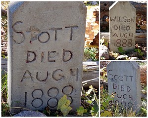
  The Hangman Trailhead & FR 86 provides access to this trail. This trail follows areas affected by the 2002 Rodeo-Chediski Fire. The Trail follows an old 2-track to the cemetery for which the trail is named. Follow the blue diamonds and stay to the right. There are logging roads that branch off to the left. A blue diamond with an arrow indicates the left-hand turn to the cemetery. The main trail continues up a rocky 2-track to FR300 east of the Black Canyon Rim Campground. The Hangman Trailhead & FR 86 provides access to this trail. This trail follows areas affected by the 2002 Rodeo-Chediski Fire. The Trail follows an old 2-track to the cemetery for which the trail is named. Follow the blue diamonds and stay to the right. There are logging roads that branch off to the left. A blue diamond with an arrow indicates the left-hand turn to the cemetery. The main trail continues up a rocky 2-track to FR300 east of the Black Canyon Rim Campground.Vigilantes lynched three men during the Pleasant Valley Feud. The Cemetery contains the gravesites for Jamie Stott, Jim Scott, and Billy Wilson. Check out the Official Route and Triplogs. Leave No Trace and +Add a Triplog after your hike to support this local community. One-Way Notice This hike is listed as One-Way. When hiking several trails on a single "hike", log it with a generic name that describes the hike. Then link the trails traveled, check out the example. | |||||||||||||||||||||||||||||||||||||||||||||||||||||||||||||||||||||||||||||||||||||||||||||||||||||||||||||||||||||||||||||||||||||||||||||||||||||||||||||||||||||||||||||||||||||||||


