Overview
From the Pigeon Spring Trailhead, the route follows FR 648, intersects with FR 143, and turns right on this road to the junction with FR 422. This road heads northwest, then west, and then north as it follows the ridgeline and keeps to roughly the same elevation. The route turns to the left (west) off of the road and onto the singletrack trail at the 11.5-mile mark. After a short climb, the trail begins a long descent towards the Sycamore Creek area. It crosses Boulder Creek several times, goes through a corral and a gate, and then parallels Boulder Creek. After crossing Sycamore Creek the trail works its way north and then west to Highway 87.
Gate Policy: If a gate is closed upon arrival, leave it closed after you go through. If it is open, leave it open. Leaving a closed gate open may put cattle in danger. Closing an open gate may cut them off from water. Please be respectful, leave gates as found. The exception is signage on the gate directing you otherwise.
When hiking several trails on a single "hike", log it with a generic name that describes the hike. Then link the trails traveled, check out the example.
WARNING! Hiking and outdoor related sports can be dangerous. Be responsible and prepare for the trip. Study the area you are entering and plan accordingly. Dress for the current and unexpected weather changes. Take plenty of water. Never go alone. Make an itinerary with your plan(s), route(s), destination(s) and expected return time. Give your itinerary to trusted family and/or friends.
Permit $$
no fees or permits reported
if incorrect tell us about it
Directions
Road
To hike
page created by joebartels on Jan 09 2010 12:41 am
 Route Editor

 Overview
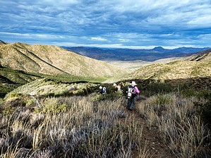


