 Route Editor

| Guide | ♦ | 22 Triplogs | 0 Topics |
details | drive | permit | forecast | route |
stats |
photos | triplogs | topics | location |
| 174 | 22 | 0 |
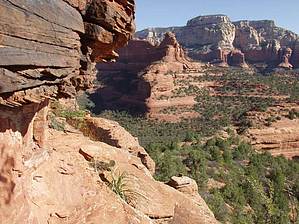
A short version of long by pbaenzig   Overview OverviewThis hike to the top of Mescal Mountain is a good side trip with Long Canyon. I find it rewarding enough to be considered a hike by itself. The minimum hiking distance is about three miles round trip, but you can easily add a mile or two to explore the top. Mescal Mountain is a mesa with a reasonably flat top. It is a bit like nearby Doe Mountain -- a smallish mesa separated from the main mountain group by a pass. Boynton Pass separates Doe Mountain from Bear Mountain. Deadman Pass separates Mescal Mountain from the nameless-on-maps mountain between Boynton Canyon and Long Canyon. Both mesas stand about 500 feet above the surrounding terrain.
The hike to Mescal Mountain starts at the Long Canyon #122 Trailhead on Long Canyon Road, about 0.6 miles after the stop sign where Boynton Pass Road branches off to the left (SW) and Long Canyon Road to the right (NE). The trailhead is on the left side of the road as you come around a curve. There are spaces for a half dozen cars and one of those tri-part information panels with usually incomplete trail information. The trail is obvious, a wide, sandy old jeep road. It heads through open terrain in a northwesterly direction. You're walking near the edge of a golf course on the right. It seems to be a pretty noisy place; there always are mechanical devices operating there, pumps and mowers and construction equipment. This aural pollution will follow you to the top of Mescal Mountain. After about 0.6 miles, you come to an old fence where the trail seems to split: two trails straight and a bit to the right (the Long Canyon trail), one less prominent trail to the left (W). This is the trail to Mescal Mountain. It's an unofficial trail, but it's generally quite obvious and has lots of hiker-made cairns. You also see the cliffs of the main body of Mescal Mountain ahead and to your left as you hike along and slowly gain height. The trail is working its way to the base of an outlying arm of the mountain (on your right) with some impressive red rock cliffs and overhangs. In about a quarter-mile, you start climbing up to a saddle. Just before you get to the top of the saddle, you have to do some light scrambling over slickrock, and you'll also see a small ruin, which, I'm told, is a vandalized Indian ruin. Once on top of the saddle, you already have a great view down to Deadman Pass. You also have the dubious pleasure of admiring the large, green golf course at Long Canyon and the expensive ticky-tack boxes of the Enchantment Resort at the head of Boynton Canyon. Several trails lead from the saddle; at least two of them seem to merge later on and get you to the top. Look for the foundations of a stone ruin, then pick one of the trails that leads south and up; if you come to an unclear part of the trail, always pick the branch that leads up. You're hiking a moderately steep scrub and rock slope up to the bottom of the actual cliffs. Once you arrive at the bottom of the cliffs (and I mean really close to the bottom, you touch the cliffs with your shoulders as you walk), turn to your left and follow the cliffs until the trail leads you to the spot where you will have to do a bit of climbing. It's easy climbing, even for a total wuss like me with a pronounced fear of heights. You're climbing up a crack in the cliff for about ten or fifteen feet, with lots of foot and handholds in the firm, grippy sandstone. You then come to a relatively flat area, hike for a few feet, and climb another ten or so feet. After the second climb, you're now on top of the mesa. The spot where you come over the edge is marked with a cairn -- try to remember its exact location, or you might find it challenging to get back down. I didn't pay attention and had a hard time finding the spot. Spend some time exploring the top of the mountain; I found it more dramatic than Doe Mountain because the mesa is more broken up. I did my hike on a hot August morning, and it was bearable, but you're exposed to the sun all the way. I decided that next time I'd do it in the afternoon or evening: you should have more shade, and the light might be more dramatic for photographs. Originally posted 08-16-03 as a Trip Log
Check out the Official Route and Triplogs. Leave No Trace and +Add a Triplog after your hike to support this local community. | |||||||||||||||||||||||||||||||||||||||||||||||||||||||||||||||||||||||||||||||||||||||||||||||||||||||||||||||||||||||||||||||||||||||||||||||||||||||||||||||||||||||||||||||||||||||||||||||||||||||


