Route Editor

| Guide | ♦ | 3 Triplogs | 0 Topics |
details | drive | no permit | forecast | 🔥 route |
stats |
photos | triplogs | topics | location |
| 68 | 3 | 0 |
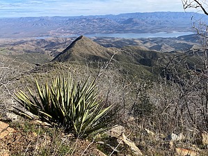
The Camelback for true hiking enthusiasts by John10s   Overview OverviewUnlike the popular, crowded, and thoroughly-signed Camelback Mountain in Phoenix, Camelback Peak (5,663') offers a very different experience: solitude, unmaintained off-trail hiking, and expansive wilderness views. Although the hike to the peak is less than six miles round-trip with moderate elevation gain, thick brush on the off-trail portion makes this a more challenging and patience-testing outing than the stats suggest, and long pants/gloves are recommended. But there's a nice payoff at the summit, with views of Four Peaks, Buckhorn Mountain, and Roosevelt Lake. Note that the hike to Buckhorn Mountain, which also starts from Mills Ridge Trailhead, is longer (~10.5 miles) and has more AEG (~3,850'), but the off-trail portion is substantially less brushy than that of Camelback, making it comparable in overall difficulty. With an elevation nearly 1,000' higher than Camelback, most hikers will find Buckhorn a more enjoyable and rewarding destination, with better views of Four Peaks and points to the west.
From Mills Ridge Trailhead, start hiking west/southwest on Four Peaks Trail #130. This portion of the hike is as good as it gets--this is part of the Four Peaks (#20) passage of the Arizona Trail, so the route is well-maintained and easy to follow. You'll steadily gain elevation, climbing ~800' over the first mile. Along the way, look for pottery on the ground, as the trail passes through several small, deteriorated ancient ruins. Around 1.3 miles in, the trail turns sharply to the left (south) to descend toward Buckhorn Crossing. The turn is the spot to leave the trail and start the bushwhack toward Camelback Peak, with the summit protruding barely in view above nearer ridges. From here, it's roughly 1.5 miles and a 1,200' climb to the peak. The official route follows a ridgeline in a relatively straight shot northwest toward Camelback, with the destination in view all the way. There are a few ridges that provide alternate routes to the peak (see triplogs for details), but the posted route is the most direct, and given the amount of brush, minimizing the off-trail distance is a major benefit. Though the route is straightforward and the grade is moderate and consistent most of the way, brush presents by far the most significant challenge from the first steps off the trail. Catclaw and thorns aren't a major issue, but manzanita, holly, and other dense foliage are relentless. Gaps in the brush are few and far between, and any small openings you can find among the branches will likely dictate the specific route you choose along the ridgeline, so use the GPS track as general guidance. You may encounter more signs of ancient habitation along the way, though any walls are badly deteriorated and difficult to see through the brush. About a mile after leaving the trail, the ridge curves more sharply to the west, and the brush finally starts to open up about a third of a mile below the peak. But the trade-off for more open terrain is a steeper grade, with a quick 400' climb in that final push. There are some loose sections on the approach, but the tread is generally solid. When you reach the top, you're rewarded with hard-earned, 360-degree views. Looking back to the east over the brushy foreground, you can see Roosevelt Lake and the Sierra Anchas beyond. Camelback Peak sits on the eastern boundary of the Four Peaks Wilderness, and visibility is more limited to the west/southwest, with the higher-elevation summits of Four Peaks and Buckhorn Mountain blocking views of more distant landmarks in that direction. Nevertheless, Camelback does offer a nice vantage point of those peaks. When you're ready to start down, brace yourself for the brush and head back toward Four Peaks Trail via the same route. It's a little easier to spot gaps in the brush going down, so the return will hopefully be a little less punishing than the approach. Check out the Official Route and Triplogs. Leave No Trace and +Add a Triplog after your hike to support this local community. | ||||||||||||||||||||||||||||||||||||||||||||||||||||||||||||||||||||||||||||||||||||||||||||||||||||||