 Route Editor

| Guide | ♦ | 10 Triplogs | 1 Topic |
details | drive | no permit | forecast | route |
stats |
photos | triplogs | topic | location |
| 155 | 10 | 1 |
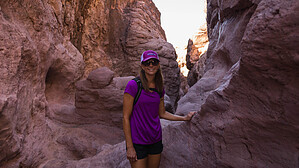
inspirational crevice by mt98dew  Overview OverviewThis is one of many hikes found at SARA (Special Activities Recreation Area) Park. SARA is located in the Aubrey Hills just south of Havasu City on 1100 acres. The park has a shooting range, BMX courses, baseball fields, rodeo grounds, a speedway (kind of like a mini PIR), a field for remote control planes, a dog park, and, oh yeah, trails. Lots of trails and some gorgeous scenery to go with them. Unfortunately, most of the trails are not signed, and many of them seem to divide and multiply like breeding rabbits, especially those near the trailheads. There are five "official" designated trailheads at this park, cleverly named: Purple, Green, Red, Blue, and Yellow. There are also close to a dozen single-track, numbered “biker” trails. I say “biker” trails because of how they twist and turn (ideal for bikes) and typically have unsigned use trails that splinter off. That being said, these trails are open to everyone. There are two main trailheads. The main one is about 0.75 miles in along McCullough Blvd, and there is a secondary trailhead about 0.25 miles further up the road. All of the main trails can be most easily accessed from the primary trailhead. There is enough parking for 20 cars, with additional parking located across the road. The TH had a bathroom, a covered picnic table, benches, and a trail map of the general area. There is no water at the TH, so come prepared.
There appear to be multiple trails that depart from this TH, and there are. But luckily, “Crack in the Mountain” (also known as the Yellow Trail, also known as trail 4456) starts as a road that heads from the southern side of the parking area. Several single-track trails immediately diverge from this dirt road, some signed, some not. Not an issue, cause initially you want to follow the road. Around 0.3 miles, the road will drop down into a dry wash, and the wash will become your trail. The wash is very large, easily 20 feet wide for most of the distance to the crack. The trail is very well marked with yellow markers to help guide the way. As long as you stay in the wash, it is not an issue. The wash can be sandy and rocky, so you might be tempted to follow the single-track trails that hug the bank of the wash. These single tracks provide a firmer surface and will fade in and out of the wash. Every once in a while, these tracks may lead out of the wash. If you end up above the bank of the wash, then you are no longer on the yellow trail, and you need to get back to the bottom of the wash. Occasionally, there will be maps (usually at major trail junctures) that provide a decent view of where you are and how the major trails interact. At 1.1 miles, the gently sloping banks of the wash become rock cliffs that begin to close in on both sides. Just before this, there will be one of those above-mentioned maps with a trail leading to the top of the wash. This trail will lead you to the Blue Trail and provides you with an alternative bypass for the “crack”. This would add to your mileage and elevation. However, if you want to get a taste of what a slot canyon is like, continue down the wash. The walls will narrow and expand for a short distance before coming together to form the slot. It’s a pretty neat experience to have the walls come together and rise above you, especially if this is your first time. You are descending as you hike down this “crack,” and there will be a couple of spots that will require the use of your arms. The first is about a sharp 7 ft drop that you can either slide down or use a rope to help lower yourself. Shortly after, there is a large boulder that has become wedged in the “crack” that you will need to climb over. The slot is over with far too quickly, and by 1.54, you have re-emerged into a wash that is very similar to what you were hiking in before the “crack”. For most people, the “excitement” is over; the “crack” has been conquered. At this point, you will notice a side trail that climbs the bank to the Blue Trail. You can use this to make a lasso or head back up the slot for the challenge, OR you can continue down the wash and visit the city’s namesake, Lake Havasu. The Yellow Trail continues down the center of the wash with the occasional “bank” trail to provide a firmer surface. The views are less inspiring in this section. The wash banks are steep and bare, with little to see beyond. At 2.35, the wash gets some character as the dirt slopes become rock walls, and then at 2.6, you reach a green wall of foliage. The trail is signed just before you enter the thick brush, and once you are in the canopy, the trail is self-evident. There will be a couple of bailout points climbing to a saddle, and eventually the trail fades, and you will be forced to climb above the bushes. There are several trails in the area, but staying on the trail that runs closest to the wash will bring you to the last yellow marker (2.74) and a fantastic view of Lake Havasu. Enjoy! Camping A unique feature of Lake Havasu is that it has 73 lakeside campsites. One of these campsites, Balancing Rock, is about 0.25 miles past the end of the Yellow Trail. This campsite is in plain sight and is easy to access from the Yellow Trail. This site has a bathroom, a covered picnic table, a trash can, and a nice level spot to pitch a tent. This is ideally set up for boaters, but I don’t think there are restrictions on hiking in and using the campsite. It is first-come come first-served serve and there is a fee for using the site. Synopsis When people think of Havasu, they don’t necessarily think of hiking, but they may want to reconsider that when it comes to the “crack”. This trail, though somewhat of a slog to start with, provides a fantastic and fairly accessible glimpse of the world of slot canyons. As a bonus, with a little additional hiking, you can enjoy the lake as well. The trail is flat and easy to follow. It can be a little challenging because of the two obstacles within the slot, but well worth the effort. Check out the Official Route and Triplogs. Leave No Trace and +Add a Triplog after your hike to support this local community. One-Way Notice This hike is listed as One-Way. When hiking several trails on a single "hike", log it with a generic name that describes the hike. Then link the trails traveled, check out the example. | ||||||||||||||||||||||||||||||||||||||||||||||||||||||||||||||||||||||||


