username
X
password
register
for free!
help
 This is likely a great time to hike this trail!  Check out "Preferred" months below, keep in mind this is an estimate. 
 

Government Hill - KNF, AZ

Guide 2 Triplogs  0 Topics
  5 of 5  
Fav
Wish
0
details
drive
no permit
forecast
route  
stats
photos
triplogs
topics
location
24 2 0
Statistics
tap row or icons for details
Difficulty 2 of 5
Route Finding 3 of 5
Distance Round Trip 2.5 miles
Trailhead Elevation 7,497 feet
Elevation Gain 930 feet
Accumulated Gain 1,046 feet
Avg Time Round Trip 1.5 hours
Kokopelli Seeds 7.73
 Interest Off-Trail Hiking & Peak
 Backpack No
unreported if dogs are allowed
editedit > ops > dogs to adjust
feature photo
Photos Viewed All MineFollowing
Inaugural Calculation on Button Tap!
14  2025-09-06 NitroTheWolf
10  2014-12-27 BEEBEE
Author
author avatar Guides 12
Routes 89
Photos 469
Trips 33 map ( 147 miles )
Age Male Gender
Location Scottsdale / Flagstaff
Associated Areas
list map done
Flagstaff Region
Historical Weather
Trailhead Forecast
Radar Map
Expand Map
Preferred May, Oct, Sep, Jun → 7 AM
Seasons   ALL
Sun  6:38am - 5:46pm
Official Route & 1 Rt
 
0 Alternative


Boulders and needles between the privates
by NitroTheWolf

 Likely In-Season! 
Expand MapOverview
Government Hill
Elevation: 8,450 feet
Prominence: 706 feet

History
Government Hill is one of the many knolls and mountains that share the Government name, located in the Flagstaff / Parks area. Why this one is called Government Hill and not Government Mountain, even though the hill has a higher elevation, is unknown.


Hike
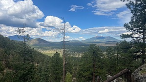
Best way up from the parking area is to follow the southernmost ridgeline as it goes up. There's a steep incline at the beginning as you climb 300 feet in a short distance, but that's probably the steepest section of the hike. As you continue up the ridgeline, there's evidence of a game trail that you can follow. Whether this trail was created by loggers or game is unknown, but it's an easy trail to follow. As you reach the summit, there's a fair amount of boulders along the ridgeline, but it's not too difficult to navigate. Not much as the summit and no summit log, at least not one I could find. Something interesting is what looks to be the ruins of a cabin at about 0.2 miles north of the summit in the saddle. While its purpose is unknown, my theory is that it was used as a storage area for logging efforts. Continue down the way you came, make sure you have good shoes as the going down can be slippery with the bed of pine needles on the ground.
remove free decal offer
Camping
Lots of dispersed camping spots on the western side of the hill. Lots of private lots around here, so heed all no trespassing signs and check a parcel map before setting up camp.

2025-09-15 NitroTheWolf


    Check out the Official Route and Triplogs.
    Leave No Trace and +Add a Triplog after your hike to support this local community.
    WARNING! Hiking and outdoor related sports can be dangerous. Be responsible and prepare for the trip. Study the area you are entering and plan accordingly. Dress for the current and unexpected weather changes. Take plenty of water. Never go alone. Make an itinerary with your plan(s), route(s), destination(s) and expected return time. Give your itinerary to trusted family and/or friends.

     Permit $$
    None


     Directions
    or
     Road
    FR / Dirt Road / Gravel - Car Okay

    To hike
    From Flagstaff, head west on Interstate-40 and exit at Parks, AZ. Head north on Park's Road, then head west on Old Route 66, then head north on Spring Valley Road. Turn west onto Forest Road 785B, open and close the gate once you pass through. Turn right (north) on the unnamed dirt road just past the gate and drive to the end of it. Park and start your hike up.
    page created by BEEBEE on Sep 15 2025 1:14 pm
    helpcorrectionissue

    end of page marker