Route Editor

| Guide | ♦ | 2 Triplogs | 0 Topics |
details | drive | no permit | forecast | 🔥 route |
stats |
photos | triplogs | topics | location |
| 19 | 2 | 0 |
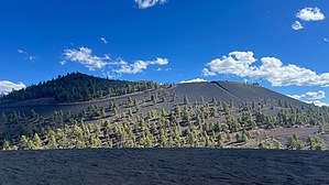
head up on the cinder, lookin' for adventure by NitroTheWolf   Warning WarningThis area is frequented by off-roaders. Watch out for people on ATVs, dirt bikes, UTVs, jeeps, and the like. Overview As the name suggests, there are two distinct craters present on this cinder cone along with a lot of volcanic rock and cinders. Since this area has been given to the off-roaders to do as they please, the hills have acquired many crisscrossing two-track trails. Since Double Crater has plenty of two-track roads to the top, there's no shortage of options on how or which way you want to approach from. Be prepared for cinders to enter your shoes while hiking.
If you don't have high clearance, you probably won't make it to the base of Double Crater. Park instead near the junction of FR 776 and FR 777 and follow FR 777 to the base of Double Crater. Add 2 miles and 500 feet of elevation gain. From the base of Double Crater, hike up the clearly defined road to the rim. This is the steepest section of the hike, with it gaining about 300 feet in 0.2 miles. At this point, you can walk counter-clockwise or clockwise around the craters. Depending on the day, you might see various off-roaders in the craters. The high point is at the southern end, and there's a summit log in a blue jar in between the two boulders. Going down is easier, especially since you don't lose a half step for every step you take. Just be careful going down the steep section. Camping Dispersed camping is plentiful along FR 776, assuming you can tolerate the noise of the off-roaders. Check out the Official Route and Triplogs. Leave No Trace and +Add a Triplog after your hike to support this local community. | ||||||||||||||||||||||||||||||||||||||||||||||||||||||||||||||||||||||||||||||||||||||||