 Route Editor

| Guide | ♦ | 4 Triplogs | 0 Topics |
details | drive | no permit | forecast | route |
stats |
photos | triplogs | topics | location |
| 32 | 4 | 0 |
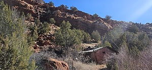
A Powerwalk to History! by azbackpackr  THE HIKE THE HIKEIMPORTANT: When you reach the parking area for Wenima Wildlife Area, the trailhead does NOT start there, although you will see what looks like a trail there. You must walk along the main dirt road, crossing the bridge over the Little Colorado River. The trailhead is on the right, just past the bridge. It is well marked, with a sign saying "Powerhouse Trail." There is a small gate you must open and shut. Before leaving the parking area, please pause to read the information in the kiosk. The area is managed for wildlife by the Arizona Game and Fish Department.
The trail ends at the powerhouse, although there is a rough route leading upriver along the length of the old flume, which brought water to the water wheel. It requires a little bushwhacking and is not an official trail. It's fairly common to see beavers swimming in the river. Even if you don't see these toothy rodents, you will see several of their dams. Binoculars are a good thing to sling around your neck, since the birdlife along this fine riparian area is abundant. Just before arriving at the powerhouse, on the left side of the trail, you might spot one petroglyph. Although this trail can be hiked in all seasons, very occasional heavy snow can block the way in winter. In summer, start very early. The inner gorge of the river is pretty hot on a July day! HISTORY AND PREHISTORY The powerhouse was built of sandstone blocks by Julius Becker in the 1920's, or before, as I recall from Becker family stories. (I can't find evidence of this online, but I once knew several members of the Becker family, and that's what they said. I can't ask them, because the ones I knew have all passed away. I will update this if I find more information.) I do know that this small hydroelectric plant once sent electricity to Springerville, in an era when small towns in this region were without power. Ancient people also lived here. The Hopi and Zuni tribes both claim ancestry. In the nearby cliffs, especially downriver on the west side, there are some fine examples of petroglyphs. There is also a pueblo close by, downriver, known as Hooper Ranch Pueblo, which was excavated in 1959 and '60 by the Chicago Natural History Museum's Southwest Archaeological Expedition. Today, stewardship is provided by the local Little Colorado River Chapter of the Arizona Archaeological Society. Before or after your visit, you can find out more about history and archaeology at the Casa Malpais Museum in Springerville, on Main Street in the same building as the police department. Archaeology of the Upper Little Colorado River Region 2.3mb PDF Other useful links: Arizona Game & Fish Dept. info Information for birders Gate Policy: If a gate is closed upon arrival, leave it closed after you go through. If it is open, leave it open. Leaving a closed gate open may put cattle in danger. Closing an open gate may cut them off from water. Please be respectful, leave gates as found. The exception is signage on the gate directing you otherwise. Check out the Official Route and Triplogs. Leave No Trace and +Add a Triplog after your hike to support this local community. One-Way Notice This hike is listed as One-Way. When hiking several trails on a single "hike", log it with a generic name that describes the hike. Then link the trails traveled, check out the example. | ||||||||||||||||||||||||||||||||||||||||||||||||||||||||||||||||||||||||||||||||||||||||


