Route Editor

| Guide | ♦ | 3 Triplogs | 0 Topics |
details | drive | no permit | forecast | route |
stats |
photos | triplogs | topics | location |
| 43 | 3 | 0 |
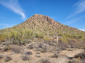
oasis in the city by Mike_W  Overview OverviewEnchanted Hills Trails is a 356-acre park on the eastern edge of Tucson Mountain Park. There are many interconnected loop trails in the park and there's also a peak on the northeastern end of the park called Enchanted Peak, which has an elevation of 2,792 feet. From this peak, it is possible to see the entire city and the area's major mountains. Hike On the west end of the parking area, there is a trail map that includes many interconnected trails including the following: El Grupo Loop Trail, Rift Trail, Fire 7 Trail, Tecolote Trail, Enchanted Peak Trail, and a few others. The El Grupo Loop Trail is the outer loop that covers most of the park.
In getting to the summit from the trailhead, the only trails I didn't use were one connector trail called High Noon (east side of the park) and 2 loop trails off to the West called the Kain Trail and the Wild West Trail. It would be possible to get to the peak and back in probably 3 miles or so, but because I hiked it the scenic way, my total distance was over 5 miles. Based on how far you want to hike you could vary your route. Overall the trails and climb to the peak were pretty easy. The final few hundred feet going to the peak involved some upper-class 2. I didn't need to use my hands but a little care should be taken to avoid sliding on the very upper portion of the trail. At the summit, there was a sign that pointed out many of the major peaks to the east, such as Tumamoc Hill, Sentinel Peak(A-Mtn), and many of the major high points in the Santa Catalina Mountains.
Check out the Official Route and Triplogs. Leave No Trace and +Add a Triplog after your hike to support this local community. | ||||||||||||||||||||||||||||||||||||||||||||||||||||||||||||||||||||||||||||||||||||||||||||||||