username
X
password
register
for free!
help


Espanto Mountain, AZ

Guide 1 Triplog  0 Topics
  2 of 5  
Fav
Wish
0
details
drive
no permit
forecast
route  
stats
photos
triplog
topics
location
12 1 0
Statistics
tap row or icons for details
Difficulty 1 of 5
Route Finding 1 of 5
Distance Round Trip 0.88 miles
Trailhead Elevation 1,293 feet
Elevation Gain 540 feet
Accumulated Gain 540 feet
Avg Time Round Trip 1 hour
Kokopelli Seeds 3.58
 Interest Off-Trail Hiking & Peak
 Backpack Possible - Not Popular
feature photo
Photos Viewed All MineFollowing
4  2024-12-18 pseudalpine
8  2019-12-22 Alston_Neal
Author
author avatar Guides 59
Routes 1,100
Photos 1,191
Trips 1,290 map ( 9,859 miles )
Age Male Gender
Location Arizona
Historical Weather
Trailhead Forecast
Radar Map
Expand Map
Preferred Nov, Dec, Jan, Feb → 7 AM
Seasons   Autumn to Spring
Sun  6:06am - 6:49pm
Official Route & 1 Rt
 
0 Alternative


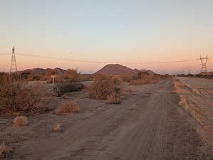
Oh, the Horror!
by pseudalpine

 
Overview
A frightening little peak located just inside the northeast corner of the Sonoran Desert National Monument and just southwest of the expansive Goodyear city limits. Portuguese and Spanish translations of Espanto list some of its meanings as awful, dismay, horror, terrible and/or terror. Each of these words could describe a hike to this mountain considering its close proximity to the Rainbow Valley Landfill. Perhaps reading a few passages of Heart of Darkness at the summit would seem apt.


Hike
The start is amongst trigger trash on the west side. Once ascending onto an upslope bajada, this unpatriotic nonsense becomes a non-issue. There's a rocky wash that can be followed and then some rock hopping on either side to the steeper summit slopes. Similarly to many of the other hikes in this area, the route isn't bushwacky and would be brutal in the hotter months.
remove free decal offer
Synopsis
Not really that horrifying of a summit since the mountain is quite a distance west of the landfill (~ 1.5 miles) and also higher than the multitude of its dump slopes. As is the case often in the Maricopa Mountains, the rumbling of passing trains is constant with an added persistent backup beeping of dump trucks. The summit also provides an elevated vantage point of Christmas Camp for reference and/or contemplation.

2024-12-18 pseudalpine


    Check out the Official Route and Triplog.
    Leave No Trace and +Add a Triplog after your hike to support this local community.
    WARNING! Hiking and outdoor related sports can be dangerous. Be responsible and prepare for the trip. Study the area you are entering and plan accordingly. Dress for the current and unexpected weather changes. Take plenty of water. Never go alone. Make an itinerary with your plan(s), route(s), destination(s) and expected return time. Give your itinerary to trusted family and/or friends.

     Permit $$
    None


     Directions
    or
     Road
    FR / Jeep Road - Car possible when dry

    To hike
    SR238 Maricopa Road at S 99th Ave. Goodyear Fire Station 187 and Mobile Elementary School are identifiable landmarks. There are also numerous communication towers near this intersection. A gas pipeline road splits northwest a quarter mile north of SR238. Follow this sometimes-sandy road for three miles until another more obscure road splits left (SW). Another quarter mile on this side road gets one close to the west side of the mountain.
    page created by pseudalpine on Dec 18 2024 9:17 pm
     90+° 8am - 6pm kills
    helpcorrectionissue

    end of page marker