username
X
password
register
for free!
help


Mesquite Hollow Trail - FHP, AZ

Guide 13 Triplogs  0 Topics
  3.3 of 5  
Fav
Wish
0
details
drive
no permit
forecast
route  
stats
photos
triplogs
topics
location
67 13 0
Statistics
tap row or icons for details
Difficulty 2.5 of 5
Route Finding 1 of 5
Distance One Way 1.5 miles
Trailhead Elevation 2,524 feet
Elevation Gain 300 feet
Accumulated Gain 525 feet
Avg Time One Way 40 minutes
Kokopelli Seeds 3.25
 Backpack No
feature photo
Photos Viewed All MineFollowing
13  2025-06-28 mt98dew
14  2025-04-17
Sonoran / Lower Sonoran Lasso Loop - FHP
DixieFlyer
5  2025-04-13
Sonoran / Lower Sonoran Lasso Loop - FHP
DixieFlyer
4  2025-04-06
Sonoran / Lower Sonoran Lasso Loop - FHP
DixieFlyer
2  2025-03-10
Sonoran / Lower Sonoran Lasso Loop - FHP
DixieFlyer
8  2025-02-28
Adero TH Wander - # who knows
FLYING_FLIVER
2  2025-02-25
Sonoran / Lower Sonoran Lasso Loop - FHP
DixieFlyer
15  2025-01-25 DarthStiller
Page 1,  2
Author
author avatar Guides 99
Routes 1,484
Photos 16,072
Trips 1,374 map ( 13,602 miles )
Age Male Gender
Location Fountain Hills, AZ
Historical Weather
Trailhead Forecast
Radar Map
Expand Map
Preferred Dec, Jan, Feb, Mar
Seasons   ALL
Sun  6:04am - 6:47pm
Official Route & 1 Rt
 
10 Alternative


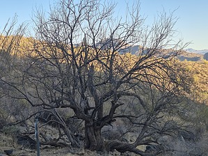
Where are the mesquite trees?
by DixieFlyer

 
Overview
The Mesquite Hollow Trail is a trail in the Fountain Hills McDowell Mountain Preserve (FHP). This is a connector trail that is most easily accessed from the Adero Canyon Trailhead in the town of Fountain Hills.


Hike
To access the Mesquite Hollow Trail, take the Promenade Trail from the Adero Canyon Trailhead. After hiking just under one mile, the Promenade Trail ends at a 4-way junction with 3 other trails: the Mesquite Hollow Trail, the Sonoran Trail, and the Lower Sonoran Trail.
remove free decal offer
Take the left fork to get on the Mesquite Hollow Trail. The trail goes for 1.5 miles to a junction with the Sonoran Trail. At that point you have some options: you can turn around and return to the trailhead the way that you came; you can turn right on the Sonoran Trail and go back to the 4-way junction and continue on the Promenade Trail back to the trailhead; or you could go left on the Sonoran Trail and after about 0.7 miles you'll come to a junction with the Lower Sonoran Trail. From there you could take the Lower Sonoran Trail back to the 4-way junction, and then take the Promenade Trail back to the trailhead. You could also use your imagination to come up with some longer routes.

The Mesquite Hollow Trail has a nice dirt surface with very little rock, so the tread is delightful to hike on. Going south to north there is some elevation gain on the trail over its 1.5 mile length: about 300 feet net and 525 feet gross. However, there are a number of switchbacks that mitigate some of the steepness.

This trail can be hiked year-round, but in warmer times of the year, it is best hiked early in the morning. There is little shade on the trail, so it is recommended to avoid hiking on the trail in the middle of the day in hot temperatures.

Water Sources
There are restrooms and water at the Adero Canyon Trailhead, but there is no water on the trail.

Camping
The FHP is only open from dawn-to-dusk, so no camping is permitted.

2025-01-03 DixieFlyer
  • 2025 Map
    area related
    2025 Map


Check out the Official Route and Triplogs.
Leave No Trace and +Add a Triplog after your hike to support this local community.

One-Way Notice
This hike is listed as One-Way.

When hiking several trails on a single "hike", log it with a generic name that describes the hike. Then link the trails traveled, check out the example.
WARNING! Hiking and outdoor related sports can be dangerous. Be responsible and prepare for the trip. Study the area you are entering and plan accordingly. Dress for the current and unexpected weather changes. Take plenty of water. Never go alone. Make an itinerary with your plan(s), route(s), destination(s) and expected return time. Give your itinerary to trusted family and/or friends.

 Permit $$
None


 Directions
or
 Road
Paved - Car Okay

To Adero Canyon Trailhead
From Loop 101 and Shea Blvd head east on Shea Blvd for 7.8 miles. Then turn left on N Palisades Blvd and continue 1.1 miles. Turn left at the stop sign onto Eagle Ridge Drive and continue 2.4 miles until you reach the Adero Canyon Trailhead. Note that along the way Eagle Ridge Drive first becomes N 143rd Way and then becomes N Eagle Ridge Drive.

• February 2019: There is road construction on Eagle Ridge Dr, and the last mile to the trailhead is on a well-graded, unpaved road. However, that section of the road will ultimately be paved.
• January 2020 FHP writes: Fountain Hills (Parks & Wildlife Dept..480-816-5100): Adero Cyn TH/Parking is presently "only" accessible for parking access at the closed chain link fence ~1 mile "prior-to" TH Parking on N. Eagle Ridge Drive. M-F Trailhead access from ~1 mile up road is only legal from 3pm daily. Sat & Sun TH access from ~1 mile up road is legal from dawn to dusk.
• 2020-02-15 Yoder writes: Road to trailhead parking is closed due to construction. You may want to go to the Sunrise Trailhead parking.
• 2020-11-09 Grasshopper writes: Officially opened, and the road to the Parking / TH is now paved.


From PHX (I-10 & AZ-51) 43 min (32.3 miles)
From TUC (Jct 1-10 & Grant) 2 h 7 min (131 miles)
From FLG (Jct I-17 & I-40) 2 h 28 min (155 miles)
page created by DixieFlyer on Jan 03 2025 1:36 pm
 90+° 8am - 6pm kills
helpcorrectionissue

end of page marker