Route Editor

| Guide | ♦ | 2 Triplogs | 0 Topics |
details | drive | no permit | forecast | route |
stats |
photos | triplogs | topics | location |
| 52 | 2 | 0 |
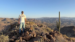
Hardly Hellish by John10s  Overview OverviewHellgate Mountain (3,339'), part of the Hieroglyphic range, is one of three named high points that fall within the boundaries of Hells Canyon Wilderness, the others being Governors Peak and Garfias Mountain. Accessible via a round-trip hike of just over three miles from Garfias Trailhead, Hellgate sits approximately 2.5 miles north of Peak 3651, the wilderness high point, and provides beautiful views of Lake Pleasant and Big Hells Gate. Hike Garfias Trailhead is a small pullout with minimal signage at the area where N. Castle Hot Springs Road turns into Cedar Basin Road on Google Maps. From the parking area, start hiking east into Garfias Wash as it twists and turns to the north/northeast, then curves back to the southeast. After following the wash for approximately two-thirds of a mile, look for a suitable spot to leave the wash and turn north to start approaching Hellgate Mountain.
Nearing the summit, you may find it easiest to head directly for the rocky ridgeline to avoid some of the cholla and brush on the slopes. As you continue north to the high point, Lake Pleasant becomes increasingly visible to the southeast. As of this writing, the summit cairn contains a register placed by Gordon McLeod and Barbara Lilley in 1998. The peak provides great 360° views of the surrounding wilderness that will leave you beaming with patriotic pride for America's natural beauty. In addition to the lake views to the southeast, Garfias Mountain and Peak 3651 are visible to the south. If you continue farther north along the ridge, you can look down at Big Hells Gate, a deep gash in the dark cliffs that gives Hellgate Mountain its name. Once you're ready to leave the summit, you can follow the same route down to Garfias Wash and return to the trailhead. The area offers plenty of intriguing options for longer hikes and loop options, including multiple peaks that make nice add-ons for extended day hikes. Check out the triplogs and/or use the deep search function to find additional route options. Check out the Official Route and Triplogs. Leave No Trace and +Add a Triplog after your hike to support this local community. | |||||||||||||||||||||||||||||||||||||||||||||||||||||||||||||||||||||||||||||||||||||