 Route Editor

| Guide | ♦ | 1 Triplog | 0 Topics |
details | drive | no permit | forecast | route |
stats |
photos | triplog | topics | location |
| 2 | 1 | 0 |
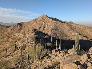
Hamming It Up with a Side of Puns by pseudalpine   Overview OverviewThis is the highpoint of the unnamed range located within BLM land at the southwestern periphery of Pinal County. This series of mountain peaks is tucked in between Peters Corner to the east, the Haley Hills to the north, the Table Top Mountains to the south, and the South Maricopa Mountains to the west. A canvass of the locals would likely uncover some interesting anecdotal names for this range. Hike The official route is a clockwise lasso loop that integrates two other adjacent significant summits and the east-side Powerline Road. From where this approach road gets gnarly, one must ascend over a saddle, then descend to a four-way intersection at a beefier tower. The western fork (Kirian Road) eventually splits, leading to a small valley, which one may ascend to Peak 2424. From there, Ham BM 2664 can be attained from the connecting northern col and undulating ridgeline. Continuing north to Peak 2558 is less involved than the hike between the first two summits. One can shorten the return hike from this third highpoint by various options instead of completing the sweeping loop.
Many of the hikes in this part of the state involve similar Sonoran terrain. Parts of the route require rock-hopping and avoiding the numerous cholla stands. Extreme bushwhacking isn't an issue because of the limited desert vegetation. Check out the Official Route and Triplog. Leave No Trace and +Add a Triplog after your hike to support this local community. One-Way Notice This hike is listed as One-Way. When hiking several trails on a single "hike", log it with a generic name that describes the hike. Then link the trails traveled, check out the example. | |||||||||||||||||||||||||||||||||||||||||||||||||||||||||||||||||||||||||||||||||||||


