 Route Editor

| Guide | ♦ | 5 Triplogs | 0 Topics |
details | drive | permit | forecast | 🔥 route |
stats |
photos | triplogs | topics | location |
| 0 | 5 | 0 |
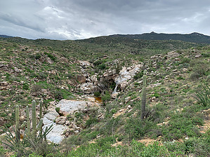
Bert must be green with envy... by John10s   Overview OverviewLocated on the eastern side of Saguaro National Park, Ernie's Falls Trail is a short spur that branches off of Douglas Spring Trail and leads to a seasonal waterfall. The most convenient access point is Douglas Spring Trailhead at the eastern end of Speedway Blvd. Note that Douglas Spring Trail gains ~1,000' of elevation over ~2.7 miles between the trailhead and the southern terminus of Ernie's Falls Trail, so although the spur to the falls is very easy, getting there does require some additional work. The well-defined trail gradually loses ~200' over roughly six-tenths of a mile, where it passes the falls shortly before reaching the Saguaro National Park boundary, marked with a sign at a gate in a barbed wire fence. The posted route ends here, but the trail does continue beyond the park boundary, though most people will likely turn around here or at the falls since that's the main attraction.
Starting from Douglas Spring Trailhead, hike east on Douglas Spring Trail for ~2.7 miles to reach the southern end of Ernie's Falls Trail at the signed three-way intersection for Douglas Spring Trail, Bridal Wreath Falls, and Ernie's Falls Trail. This is the point where the posted official route begins. Along the way, you'll pass intersections with several other trails that branch off of Douglas Spring: Garwood Trail (~0.25 miles from the trailhead), Converse Trail (~0.7 miles in), Carillo Trail (~1.7 miles in), and Three Tank Trail (~2.5 miles in). When you reach the Ernie's Falls intersection, turn left to begin hiking north. Ernie's Falls flow over a north-facing rock outcropping, so they aren't visible until the trail passes west of the falls and turns to the east about a half mile into the route. This is one of the best viewpoints of the falls from the trail. If you want to go down to the base of Ernie's Falls, continue a little farther down the trail, then follow the wash back to the south for a closer view. When you're done exploring, you can hike back to Douglas Spring Trail and return to the trailhead via the same route. Gate Policy: If a gate is closed upon arrival, leave it closed after you go through. If it is open, leave it open. Leaving a closed gate open may put cattle in danger. Closing an open gate may cut them off from water. Please be respectful, leave gates as found. The exception is signage on the gate directing you otherwise.
Check out the Official Route and Triplogs. Leave No Trace and +Add a Triplog after your hike to support this local community. One-Way Notice This hike is listed as One-Way. When hiking several trails on a single "hike", log it with a generic name that describes the hike. Then link the trails traveled, check out the example. | |||||||||||||||||||||||||||||||||||||||||||||||||||||||||||||||||||||||||||||||||||||||||||||||


