Route Editor

| Guide | ♦ | 2 Triplogs | 0 Topics |
details | drive | no permit | forecast | 🔥 route |
stats |
photos | triplogs | topics | location |
| 3 | 2 | 0 |
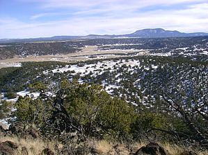
Get a Round To It! by azbackpackr   The first mile of this hike is via the Flat Top Trail. The trailhead is at the corner of 12th Street and Line Street, off of Water Canyon Road, in Eagar. (It is not the Murray Basin Trailhead, although you could approach it that way if you wanted to.) These directions start at the main Flat Top trailhead. The first mile of this hike is via the Flat Top Trail. The trailhead is at the corner of 12th Street and Line Street, off of Water Canyon Road, in Eagar. (It is not the Murray Basin Trailhead, although you could approach it that way if you wanted to.) These directions start at the main Flat Top trailhead.Hiking about 1.3 miles up Flat Top Trail, you'll come to a major junction. This is as good a point as any to start your bushwhack (meaning, there is no trail) to the summit of Round Mountain, which can be seen to the right, or south, as you are approaching the junction. You can't see the actual summit from here, but just head uphill using my route. Just keep heading uphill, dodging piñons and junipers, and you'll get there! It's not far.
Round Mountain is on various peakbagger lists, because it has enough prominence to qualify. There is a summit register, although at this writing it is in bad shape, having become moldy. You can still write in it, however. You will have to hunt for it, and replace it as you found it, under a rock. I'm thinking about replacing it, or at least, getting a better jar, and adding a new notebook. Check out the Official Route and Triplogs. Leave No Trace and +Add a Triplog after your hike to support this local community. | |||||||||||||||||||||||||||||||||||||||||||||||||||||||||||||||||||||||||||||||||||||||||||