username
X
password
register
for free!
help
 
  🔥

Grand Wash Bench Trail, AZ

Guide 1 Triplog  0 Topics
  3 of 5  
Fav
Wish
1
details
drive
no permit
forecast
🔥
route  
stats
photos
triplog
topics
location
25 1 0
Statistics
tap row or icons for details
Difficulty 3 of 5
Route Finding 1 of 5
Distance One Way 11.72 miles
Trailhead Elevation 3,693 feet
Elevation Gain 1,124 feet
Accumulated Gain 1,576 feet
Avg Time One Way 5 hours
Kokopelli Seeds 16.97
 Backpack Yes
feature photo
Photos Viewed All MineFollowing
Will recalculate on button tap!
25  2025-10-18 GrangerGuy
Author
author avatar Guides 35
Routes 144
Photos 1,025
Trips 117 map ( 1,425 miles )
Age 69 Male Gender
Location Phoenix, AZ
Associated Areas
list map done
Northwest Region
Historical Weather
Trailhead Forecast
Radar Map
Expand Map
Preferred Oct, Nov, Mar, Apr → 7 AM
Seasons   Autumn to Spring
Sun  7:31am - 5:19pm
Official Route
 
0 Alternative
 
Historic Fire Perimetersacres
🔥 2012 Hobble Complex Fire64.9 mi*
🔥 2006 Birthday Complex Fire16.9 mi**
🔥 2005 TWEEDY COM Fire44.2 mi*
🔥 2005 Tank Fire42.0 mi*
🔥 View (All) - over Official Route 🔥
*perimeter length in miles
**possible voids inflate figure


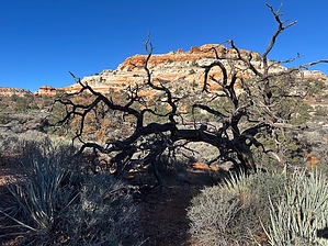
Grand Views -- and a Seat to Yourself
by GrangerGuy

 
Expand MapOverview
The trail runs for 11 miles, almost the length of the wilderness from north to south along a bench between the cliffs of the Hidden Rim up to the east and the Grand Wash Cliffs down to the west, with the Grand Wash beyond. It is an easy walk with spectacular, wide-open views the whole trip. The real challenge is getting there.


Hike
The north end of the trail is along BLM Road 1003 in Hidden Canyon at the northeast corner of the wilderness. Just off road 1003 is the trailhead sign and a trail register, and the trail continues along a 4x4 road about 0.6 miles to the wilderness boundary and a locked gate. Park at either place.
remove free decal offer
The trail climbs steadily about a thousand feet in the first 5 miles, and then rolls gently up and down as it continues south. This is a pretty gentle hike. The trail is an old two-track through the wilderness, which, it seems, the BLM drives from time to time on patrol. One can either think optimistically of this as a wide and easy trail or pessimistically as just another road walk.

The views never stop. As you head south, the cliffs of the Hidden Rim appear on the east. The views to the west just go on and on. Although you only rarely see down into the Grand Wash itself, you can see the Cottonwood Ridge on the other side, and beyond to the Virgin Mountains and beyond.

At 11.7 miles, you arrive at the gate at the southern end of the wilderness. This is a good place to turn around, or you can do the hike as a shuttle.

Water Sources
There is a tank about 4 miles from the north trailhead, but one would be smart to carry all the water you need for this trip.

Gate Policy: If a gate is closed upon arrival, leave it closed after you go through. If it is open, leave it open. Leaving a closed gate open may put cattle in danger. Closing an open gate may cut them off from water. Please be respectful, leave gates as found. The exception is signage on the gate directing you otherwise.

2025-10-28 GrangerGuy


    Check out the Official Route and Triplog.
    Leave No Trace and +Add a Triplog after your hike to support this local community.

    One-Way Notice
    This hike is listed as One-Way.

    When hiking several trails on a single "hike", log it with a generic name that describes the hike. Then link the trails traveled, check out the example.
    WARNING! Hiking and outdoor related sports can be dangerous. Be responsible and prepare for the trip. Study the area you are entering and plan accordingly. Dress for the current and unexpected weather changes. Take plenty of water. Never go alone. Make an itinerary with your plan(s), route(s), destination(s) and expected return time. Give your itinerary to trusted family and/or friends.

     Permit $$
    None


     Directions
    or
     Road
    Strictly 4x4

    To hike
    We took BLM 1069 south from UT-7 near Saint George to BLM 1004 at Wolf Hole Valley, where we turned right. After 1/4 mile, we turned left on County Road 101 to BLM 1032. At the intersection with BLM 1033, we turned left into Jump Canyon. Near the bottom of Jump Canyon, we encountered an impossibly deep washout in a wash that we were able to work around by heading left along a track along the wash to a corral. At the corral, we were able to cross the wash and pick up BLM 1033 again. Continuing down to the wilderness boundary, we turned left on 4x4-only BLM 1003 to the trailhead. The Avenza app with the geocoded Arizona Strip West map is highly recommended.

    One might consider at Wolf Hole Valley going straight on County Road 5 to its intersection with County Road 103. Turn right on CR 103 where it intersects BLM 1003. Turn right on BLM 1003 and follow it to the trailhead. The BLM map suggests these might be better-maintained roads.
    helpcorrectionissue

    end of page marker