Route Editor

| Guide | ♦ | 21 Triplogs | 0 Topics |
details | drive | no permit | forecast | route |
stats |
photos | triplogs | topics | location |
| 19 | 21 | 0 |
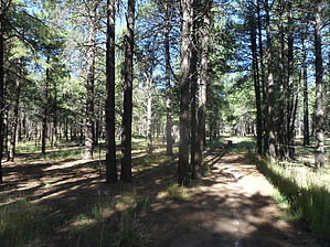
Do you want to be a soldier? by Shilo   Overview OverviewThe Soldiers Trail is part of the recreation complex of the Coconino County fairgrounds at Fort Tuthill. The trail makes a nice loop around the perimeter of the fairgrounds Hike At the fairground parking lot, the trailhead will be along the east perimeter. There is a sign marking the trailhead with a map. From the trailhead sign, you'll head north along the Sinclair Wash Urban Trail for 0.5 miles. You'll come across another sign that describes the Soldiers Trail. At this point, you will want to go left or right, for whichever way you go will eventually bring you back to this point for a complete loop. I would recommend going left, for the most challenging part of the trail will be over after 1.5 miles. You'll notice right away that the Soldiers Trail is well marked with green laths with directional arrows. The trail will take you west along the northern fence line and up a gentle grade. The trail will then turn south, giving you a little rest before the next significant incline. At the 1.5-mile point, the trail will fork. You have the option of shortening your hike by 0.75 miles if you turn left. Going left here will take you 1.25 miles south to reconnect with the larger loop. Turning right at this point will take you up a steep canyon to the trail's highest point at mile 2.0. The trail turns north again, then west, then south along the western perimeter of Fort Tuthill. As the trail travels south, you'll notice a distinct difference in forest management. On your right, a heavy thinning allows you to view far into the woods, whereas the non-treated forest on your left is thick and heavily wooded.
Check out the Official Route and Triplogs. Leave No Trace and +Add a Triplog after your hike to support this local community. | ||||||||||||||||||||||||||||||||||||||||||||||||||||||||||||||||||||||||||||||||||