Route Editor

| Guide | ♦ | 43 Triplogs | 2 Topics |
details | drive | no permit | forecast | 🔥 route |
stats |
photos | triplogs | topics | location |
| 577 | 43 | 2 |
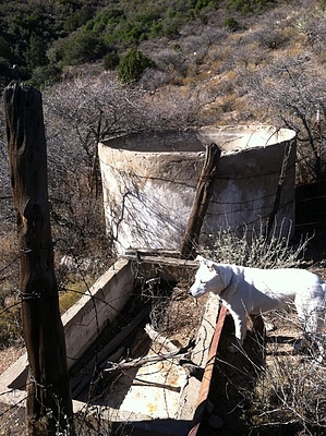
the Cuff Nasty Experience by FOTG  Brief Overview Brief OverviewCuff Button offers hikers a chance to draw a line on their map through a seldom traveled area of the Superstition Wilderness. Like, many other trails in the Superstition wilderness, Cuff Button started as a road, apparently used to service the several, now in disrepair troughs, tanks, and springs along the route. Today, there is still certainly evidence of the old road along various sections of the trail. However, a lack of maintenance, remoteness, and accessibility have taken their toll on the old Cuff Button road. It is severely overgrown and even difficult to follow in places. Warning This hike is probably a hike you would want to do with a partner and, ultimately, a GPS with a downloaded route to be safe. A partner would also enable you to make this a shuttle hike with one person leaving a vehicle at Miles TH and then driving together to Cuff Button TH. In terms of driving to the trailhead, it may be the biggest challenge of the day for some. The trail head is located just over ten miles by winding roads off U.S. 60, just past The Top of the World, utilizing the entrance of Pinto Mine. It can be a confusing ant-trail like a network of roads with many turns and dead ends. During the final portions of the drive, the road gets progressively worse and then eventually devolves into a path up the creek bed, but by no means too much for most four-wheel-drive vehicles to handle. However, the overgrown road is a bad combination for nice paint jobs on newer cars, so one might want to park a little before the trailhead and walk 0.5-1mi or so extra in by foot.
This hike starts at the Cuff Button Trailhead and follows the generally southwestern route of Cuff Button to its ending point at its intersection with the W. Pinto Trail in the Oak Flats area. The first 2.5 miles of the trail are nothing like the bushwhack described in the overview. In fact, Cuff Button was definitely the recipient of some major trail maintenance rather recently. From the trailhead to Cuff Button's most notable attraction, the post and rail corral, the trail is very wide, and easy to follow, complete with very large rock baskets marking/anchoring old fencing lines and gates. Along this section, one will also pass what is marked as Burro Spring on the map. There was already seasonal water along this route, so it's hard to judge the reliability of water at this spring. However, there were cat-tails. I did not look extensively for a trough or spring box, and I assume Burro Spring amounts to a seep somewhere in the creek bed/wash near Burro Spring on the map. After reaching the post and rail corral, the trail gets progressively worse and amounts to a bushwhack in many places as the trail makes its first real climb of the hike. Once you reach the higher elevations of Cuff Button, the trail is much easier to follow and less overgrown, although there are still several sections of the trail nearly choked off with acacia. The old road still leaves a heavy easy to identify tread that can be viewed far into the distance as it winds and dips across various ridges and draws/washes. Take a moment to try and pick up the trail's tread in the distance to gain a better idea of your route and future directions of travel. One can enjoy some very panoramic views during this portion of the trail. Some notable terrain features include: Pinto Peak, Saw Tooth Ridge, Iron Mountain, and even views across the Lake Roosevelt area into the Sierra Ancha. You will pass multiple springs that will serve as frames of reference for you as you make your way across the higher elevations of Cuff Button. At about the halfway point, you will pass a random rock basket. This basket marks the old anchor for the gate entering Wildcat Canyon and the route of an old horse trail that heads south to the Miles TH area. If one feels adventurous, Jack Carlson and Elizabeth Stewart provide a hike description for this ancient route to Miles TH in their book Superstition Wilderness Trails East. The authors also note that some of the springs along Cuff Button may be mislabeled or go by multiple names. For example, most maps will show two Cuff Button Springs. However, the one furthest east should be labeled Thicket Spring rather than Cuff Button. However, most of this is moot, as all of these springs are in disrepair and amount to little more than hard to locate seeps and piles of old piping. The most notable spring and corral area along this portion of the trail is Sycamore Spring. The CCC constructed this spring and the large tank. However, according to Jack Carlson and Elizabeth Stewart, this spring was doomed from the start, as local ranchers said, its design was poor. After passing the Sycamore Spring tank and corral area, if you keep a close eye on the trail once you cross the first major wash, you will see an old metal trough/tub right off the edge of the trail in the middle of the wash, this is Tub Spring. I am assuming from pipes that it drew its water from the same source as the tank at Sycamore Spring. You will also see several prehistoric sites and some pottery shards along this route. Please remember rules and etiquette regarding prehistoric sites. The trail will hit another pretty overgrown stretch as it makes its way down the final ridge into the Oak Flats area. This part can be really tough to follow in spots. You will know if you wandered off-trail if you have to cross a fence to make your final descent. The trail will slowly make it's way closer to the major drainage that runs south into the W. Fork of Pinto Creek. The final section of the trail will pass Jerky Spring as it hugs the western edge of the above-mentioned drainage while it makes its way south to the intersection with W. Pinto in the Oak Flats area. I did not see any signs of troughs or even the possibility of a spring at the location of Jerky Spring. However, I speculate Jerky Spring, like many others in the Eastern Superstitions, is labeled or marked incorrectly. A more appropriate location would be further north up the wash, where I spotted a concrete well and corral area. However, this is speculation, and I assume both locations are not reliable water sources. In terms of reliable water, after completion of Cuff Button, approximately a half-mile east down W. Pinto is a significant pool of water that seems to hold water year-round, or at least when everywhere else is dry from my past experiences. My best guess to the name of this spring would be Oak Flat Spring. However, it's again speculation, as my map seems to have Oak Flat Spring further west than the location described above. Final Points to Consider I would strongly recommend a GPS and downloaded the map for this hike. Likewise, if inexperienced in route-finding, this hike may not be for you, or I would consider taking a partner along. Similarly, the lack of water and reliable springs along this trail certainly make it a candidate for the winter hiking season. Finally, everything from the trail to the trailhead is rugged and remote. Therefore, a certain trail/outdoors savvy and an ability to be self-reliant, with some experience in route finding, are necessary to complete this trail, as you will almost certainly not run into anyone else along the route. Gate Policy: If a gate is closed upon arrival, leave it closed after you go through. If it is open, leave it open. Leaving a closed gate open may put cattle in danger. Closing an open gate may cut them off from water. Please be respectful, leave gates as found. The exception is signage on the gate directing you otherwise. Check out the Official Route and Triplogs. Leave No Trace and +Add a Triplog after your hike to support this local community. | |||||||||||||||||||||||||||||||||||||||||||||||||||||||||||||||||||||||||||||||||||||||||||||||||||||||||||||||||||||