Route Editor

| Guide | ♦ | 8 Triplogs | 0 Topics |
details | drive | no permit | forecast | 🔥 route |
stats |
photos | triplogs | topics | location |
| 80 | 8 | 0 |
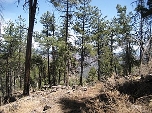
Short & Sweet Rose Peak by PhilipMueller  The hike up the Rose Peak Trail in the Blue Range Primitive Area in Eastern Arizona is short, and the views from the top are SWEET! Whether you are heading out for a longer hike in the Blue Range and want to get the "lay of the land", or you need to stretch your legs and slowly examine the incredible beauty through which you are riding/driving on the winding US-191 (Coronado Trail), a few minutes of your time hiking up the Rose Peak Trail will be well worth it. The hike up the Rose Peak Trail in the Blue Range Primitive Area in Eastern Arizona is short, and the views from the top are SWEET! Whether you are heading out for a longer hike in the Blue Range and want to get the "lay of the land", or you need to stretch your legs and slowly examine the incredible beauty through which you are riding/driving on the winding US-191 (Coronado Trail), a few minutes of your time hiking up the Rose Peak Trail will be well worth it.The trail is a pleasant half-mile long, consisting mostly of pine-covered switchbacks. While it is a short hike, note that the Rose Peak Trail starts at an elevation of 8,426 feet and ascends 360 vertical feet. With its high elevation and decent rise overrun, those with a sedentary lifestyle should not underestimate it. After you feel that fresh mountain air in your lungs and you have your blood pumping just a bit, you will quickly be atop the 8,786 ft peak where you'll find an approximately 30-foot tall fire lookout tower, a bathroom, a cistern, and a little cabin that you'll wish was yours.
Check out the Official Route and Triplogs. Leave No Trace and +Add a Triplog after your hike to support this local community. | ||||||||||||||||||||||||||||||||||||||||||||||||||||||||||||||||||||||||||||||||||||||||||||||||||||||||||||