Route Editor

| Guide | ♦ | 1 Triplog | 0 Topics |
details | drive | no permit | forecast | route |
stats |
photos | triplog | topics | location |
| 79 | 1 | 0 |
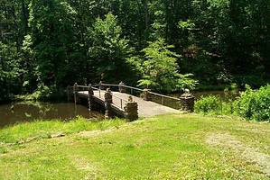
 Hot Springs National Park Hot Springs, Arkansas 71913 Overview The Sunset Trail is the longest trail in the Hot Springs National Park, covering approximately 10 miles when done as a one way. Using intersecting trails it can be done as a loop, approximately 13.5 miles in length.( see accompanying GPS download). Crossing all types of terrain, the trail passes by the highest elevation in the Park (approx 1400feet) as well as Rick’s Pond, the Stone Bridge, Dam, Water Wheel Mill, Bath House Row and Downtown Hot Springs. It ends at Gulpha Gorge Campground. Hike This trail starts at the West Mountain Summit Overlook. When doing this trail as a loop, the starting point is the ending point of the one way at Gulpha Gorge Campground. At the Amphitheater, cross the dam and take the trail to your left. This is the Dead Chief Trail to Downtown and Bath House Row. Make sure you stay on the trail as there are numerous side trails. All are marked clearly. You will exit the trail to the Promenade, look for the stairs that descent to Bath House Row and Central avenue. Cross the street at the stop sign and on the west side to your left is a Street called Mountain St. turn right and ascend to Exchange street on your right. Follow this to your right by a gate and continue until you reach a gravel trail that runs north and south. Take the trail to the left (south) this is Oak Trail.
This trail is generally moderate with a few spots that are of a strenuous nature. Take plenty of water and there are no toilet facilities once you get out of downtown and the campgrounds. Do not do this hike if there is pending inclement weather and storms forecasted as high winds can bring trees crashing down around you. This hike is 98 % under the canopy. Ticks are out when it's warm outside. Use a spray to deter and every now and then check your legs. Route finding skills is a 1 out of 5. The trail is almost like a small gravel road. Well maintained throughout, except the areas that were eroded by last weeks storms and heavy rain. Always helps to have a GPS especially when using numerous trails as you do in the Park proper. Mainly West and Hot Springs Mountains Trails. If you don’t have a GPS stop at the resident campground site and ask for a map. It is titled “Visiting Hot Springs”. Hot Springs National Park Arkansas. Enjoy! Gate Policy: If a gate is closed upon arrival, leave it closed after you go through. If it is open, leave it open. Leaving a closed gate open may put cattle in danger. Closing an open gate may cut them off from water. Please be respectful, leave gates as found. The exception is signage on the gate directing you otherwise. Check out the Official Route and Triplog. Leave No Trace and +Add a Triplog after your hike to support this local community. | ||||||||||||||||||||||||||||||||||||||||||||||||||||||||||||||||||||||||||||||||||||||||||||||||