 Route Editor

| Guide | ♦ | 8 Triplogs | 0 Topics |
details | drive | permit | forecast | route |
stats |
photos | triplogs | topics | location |
| 37 | 8 | 0 |
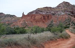
Palo Duro's Iconic formation by markthurman53  Palo Duro Canyon is located 25 miles southeast of Amarillo Texas, in the Texas panhandle, and is the second-longest canyon in the US; you can guess the first. The creek that runs through the canyon is part of the Prairie Dog Town Fork of the Red River. The canyon formed when the river cut down through the Llano Estacado Plateau as it was uplifted during the Pleistocene Period. This canyon has been called the Grand Canyon of Texas. The rock formations are of the Permian and Triassic periods. The lower Permian section was formed when this was a near-shore shallow marine environment. The upper Triassic layer was formed when this was a stream environment and formed the Sandstone cap rock of the park. Palo Duro gets its name from the Spanish, meaning “hard stick”. This area was first occupied by Native Americans, the Apaches and then replaced by the Comanche and Kiowa. It was visited by Coronado in 1541, then around the 1870’s ranching. It became a state park in the 1930s. A lot of history was glanced over in those last few sentences; more detail is readily available online.
LIGHTHOUSE TRAIL Overview The Lighthouse is the iconic rock formation of Palo Duro Canyon. This 3-mile one-way trail passes along some of the park's most interesting formations, Capitol Peak, Capitol Mesa, and Castle Peak. This trail is a fairly easy walk along Sunday Creek and further in, Little Sunday Creek. The last quarter mile involves a little bit of elevation gain, but the trail is good. Allow for extra time to explore off trail a bit as I can guarantee you will want to do that. There are multiple trails in the area, so you can take alternate routes back with the park map. Description The Trailhead parking is about halfway in on the park drive on the west side just past the second bridge crossing of the Prairie Dog Town Fork of the Red River. The trail starts out heading west toward Capitol Mesa and at 0.4 miles turns north to skirt the east side of Capitol Mesa and Capitol Peak. The trail is now up against the red eroded sides of Capitol Peak. This is a good area to explore the eroded hills more closely. The trail continues north over a small rise before entering Sunday Flats and Sunday Creek. For the next mile, the trail heads west along the north side of Capitol Mesa. The hillsides are bare of vegetation and multicolored, much like the Chinle Formation of northern Arizona. The walking is easy along this stretch, wide red clay path through Mesquite trees and shrubs. The next section of trail heads in a more southerly direction, and the lighthouse can now be seen in the distance. The trail still easy to walk becomes a little rockier along this stretch as you cross over the normally dry Little Sunday Creek a couple of times. The last 0.4 miles to the lighthouse, the trail gains about 200 feet in elevation. This elevation gain is done on an easy-to-follow trail and passes through small breaks in the rock ledges. This is easy enough for even the most novice hikers. Once at the lighthouse, there are a couple of options for getting up to the shelf between the two towers, one from the north the other from the southwest; either is easy. The views from the terrace between the two towers are good, not spectacular, but then I’m used to more of the mountain top views of Arizona. This hike’s rewards are well worth the small amount of effort you have to put into it.
Check out the Official Route and Triplogs. Leave No Trace and +Add a Triplog after your hike to support this local community. One-Way Notice This hike is listed as One-Way. When hiking several trails on a single "hike", log it with a generic name that describes the hike. Then link the trails traveled, check out the example. | ||||||||||||||||||||||||||||||||||||||||||||||||||||||||||||||||||||||||||||||||||||||||||||||||||||||||||||||||||||||||||||||||||||||||||||||||||||||||||||||||||||||||||||||||||||||||||


