I almost fear giving out this great hike, but the views are spectacular, and the end of the trail holds a great reward. Roger's Canyon Trail will lead you to a pristine cliff dwelling at the end of a 4-mile hike down the canyon trail. Part of the allure and enjoyment of this trail is just getting to the trailhead (you'll start your hike from Rogers Trough Trailhead). Your drive in will be packed with great views of the Superstitions, the valley (well, at least the east valley), some fantastic rock formations, and desert flora. If you're looking for an incredible Sunday drive to show those visitors from back east the beauty of the desert, this is an excellent drive in its self. But the hike (over 8 miles round trip) is worth every step.
I cannot stress enough to BRING WATER!!! The trail descends the canyon to the cliff dwells for 4.1 enjoyable miles. But remember that what goes down must come up (or something like that). And the hike out is all uphill, and you'll need your water, even if you're a seasoned hiker. On a recent trip, one person in our party became partially dehydrated. Lucky for us, we had all packed in plenty of water (more than one bottle per person), approximately two large canteens each. The trail leaves the trailhead and travels about 1.6 miles to the junction with Reeves Ranch trailhead. The trails and junction are well marked. The trail drops into Rogers Creek and follows the creek for most of the way to the cliff dwellings. Juniper and manzanita trees are abundant along this part of the trail. This means that the trail is shaded for parts of the hike, depending on the time of day.
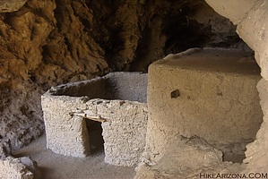
After leaving the junction, it is approximately 2.5 miles to the cliff dwellings (a total of 4.1 miles from the trailhead, so be prepared for the uphill trip back). The dwellings are visible from the trail, and there are several there to view. Remember that the Antiquities Act protects these dwellings, so treat them with the respect they deserve! They have been there for over 700 years, and we don't want some 20th-century moron to destroy them for future generations. So, please explore them, enjoy them, take pictures, imagine what it was like for the people that once lived there, but don't dig around them, and don't climb on the walls or roofs.
Leave only footprints and only bring back memories of a great hike.
WARNING! Hiking and outdoor related sports can be dangerous. Be responsible and prepare for the trip. Study the area you are entering and plan accordingly. Dress for the current and unexpected weather changes. Take plenty of water. Never go alone. Make an itinerary with your plan(s), route(s), destination(s) and expected return time. Give your itinerary to trusted family and/or friends.
Permit $$
None
Directions
Road
High Clearance possible when dry
To Rogers Trough Trailhead Take US 60 east out of Apache Junction. A couple of miles past Florence Junction turn north onto Queen Valley Road and follow 1.6 miles. Turn right onto FS 357 (Hewlett Station Road) and follow about three miles to FS 172. Turn left onto FS 172 and follow this for 9.1 miles (keep an eye out to your right near the four-mile mark for a thin arch) to FS 172A.
Turn right onto FS 172A and follow 3.8 miles to the Rogers Trough Trailhead. While an occasional abused sedan negotiates the drive, high clearance is highly recommended. Without 4WD you might be in serious trouble if it rains.
This scenic drive wrecks havoc on passengers with weak stomachs.
 Route Editor

 I almost fear giving out this great hike, but the views are spectacular, and the end of the trail holds a great reward. Roger's Canyon Trail will lead you to a pristine cliff dwelling at the end of a 4-mile hike down the canyon trail. Part of the allure and enjoyment of this trail is just getting to the trailhead (you'll start your hike from Rogers Trough Trailhead). Your drive in will be packed with great views of the Superstitions, the valley (well, at least the east valley), some fantastic rock formations, and desert flora. If you're looking for an incredible Sunday drive to show those visitors from back east the beauty of the desert, this is an excellent drive in its self. But the hike (over 8 miles round trip) is worth every step.