 Route Editor

| Guide | ♦ | 4 Triplogs | 0 Topics |
details | drive | permit | forecast | route |
stats |
photos | triplogs | topics | location |
| 66 | 4 | 0 |
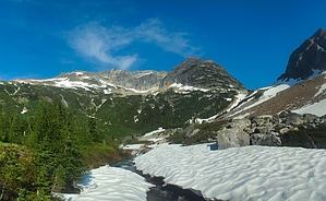
Lightning optional by nonot A multi-day trip to Park Creek Pass. Most will want at least 3-4 days for an out and back to visit park creek pass and return. Statistics listed are for a one-way trip to the pass. Continuing onto Park Creek Trail is possible for those seeking more adventure! Warnings and Red Tape The park has rules regarding Bear canisters and permits are required for all campgrounds. Also, dogs are allowed only on the first 7.5 miles of the trail, you may not take your dog past the national recreation boundary into the national park. Due to snow people should carefully plan their trip - before July crampons will likely be required, and the park may limit access/close the trails at certain times due to both weather conditions and animal (nesting) concerns. I believe this trail typically opens up early in July for general usage.
You will pass the Skagit Queen Mine remnants on this hike. Hike From the very back of Colonial Creek Campground, the trail heads along the Thunder Creek Arm of Diablo Lake and follows Thunder Creek at approximately creek level for the first 1.3 miles before passing over a sturdy bridge and reaches the Thunder Creek Campground at around mile 1.4. You shortly pass the turnoff to Neve campground, while the trail proceeds to climb quite a bit above creek level. As you continue along you can hear the creek thundering below you (hence the name) but cannot see much as you walk amongst the monstrous trees of the Pacific northwest on the edge of a rather precipitous slope. For the next few miles you will pass over several small streams flowing down from higher up on the mountain. At mile 6.5 you return to Creek level and pass McAllister Horse camp, and shortly after the turnoff to McAllister hiker camp (cross the bridge to access the camp on the other side of the creek.) The views of the creek here are quite nice and you may want to spend a few minutes admiring them. You will stay again leave the creek until you cross the bridge of Fisher Creek and reach the Tricouni campground turnoff at mile 7.8. Those who were seeking a less strenuous adventure should turnaround here - Tricouni camp makes a good turnaround for a (long) day hike as well. The next mile of trail is perhaps the toughest as you begin a very steep ascent up a ridge near Fisher Creek. Along this climb, if you peer to your left you will hear (and kind of see) a pretty significant waterfall. The trail will level and at mile 10.5 you reach Junction Camp along Fisher Creek (bear canisters required here). Junction camp is named because of the junction with the Fisher Creek Trail. Turn right at the junction to stay on the Thunder Creek Trail. Over the next 2 miles, the trail will descend, steeply at some points, to again reach Thunder Creek. As you follow the creek you will begin to gradually ascend, and cross a bridge right before Skagit Queen campsite (pack hanging allowed) at mile 14. After this you will proceed up a steep series of switchbacks and cross by the remnants of the Skagit Queen mine where you can view a mine cart and some other equipment aging in the woods. The trail will level as you enter into the upper Thunder Basin. You will observe waterfalls around you from all the melting snow and glaciers. The trees here are smaller as you ascend into the alpine zone, finally reaching Thunder Basin campsite at mile 19.5 (bear canisters required.) The remaining 3 miles will likely be slow going due to snow bridges, creek crossings, waterfalls, and downed/crushed trees. The trail switchbacks and you may encounter lots of snow. Traction devices will be helpful if you thought to bring them. Crampons may be needed depending on snow depth. The final ascent up to Park Creek Pass will allow you an overview of the upper basin and the final traverse onto the snowfield of the pass will help to cool you off after the climb. Keep going ahead and down the Park Creek Trail, or turnaround back the way you came. Water Sources Numerous creek crossings, streams, and Thunder Creek itself at certain access points. Camping Numerous options, see the description above. Permits are required for all campsites. Check out the Official Route and Triplogs. Leave No Trace and +Add a Triplog after your hike to support this local community. One-Way Notice This hike is listed as One-Way. When hiking several trails on a single "hike", log it with a generic name that describes the hike. Then link the trails traveled, check out the example. | |||||||||||||||||||||||||||||||||||||||||||||||||||||||||||||||||||||||||||||||||||||


