 Route Editor

| Guide | ♦ | 6 Triplogs | 0 Topics |
details | drive | permit | forecast | map |
stats |
photos | triplogs | topics | location |
| 93 | 6 | 0 |
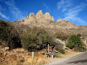
Just Nice... by imike  The elevations given orient from the east side of the range in the BLM camping park area. In fact, if you are hiking up and over the pass, and down the west side, to get back to your car you need to plan on descending to the 4900' mark... which means you will have to climb back up over 1400'. There are some rolling ups and downs... so... 12 miles and over 2300' of Accumulated Elevation Gain for the out and back, no matter which side of the mountain you park on, if you do the entire trail.
The access from the BLM side requires a parking fee. The parking area from the west side of the mountain, off Baylor Canyon Road is still free. The trail offers great vista views of the surrounding peaks, winding you along and underneath the massive spires of the Rabbit Ears. It is a nice trail. Be aware of the seasonal parking hours for the BLM section: 8am to 5pm in the Winter... expanding to 7pm after March. If you are going for a later start, or planning to be slow... or late, consider accesses from the west side of the mountain. To reach the East side access: follow Highway 70 to just below the San Augustin Pass on the east side, and turn into the signed entry for the Aquirre Springs Recreation Area. Follow the paved road up and into the one way loop portion, and look to your right for the trailhead sign. There is a sign in log and a self serve fee station. If you miss those, stop at the next fee station just up the road; that one is very obvious. You can pay and park up there by the rest rooms, walking the short distance back down to the trail head. If you want to start your hike from the Las Cruces side of the mountain, simply follow Baylor Canyon Rd south off of the Highway 70 road. Check out the Triplogs. Leave No Trace and +Add a Triplog after your hike to support this local community. One-Way Notice This hike is listed as One-Way. When hiking several trails on a single "hike", log it with a generic name that describes the hike. Then link the trails traveled, check out the example. | |||||||||||||||||||||||||||||||||||||||||||||||||||||||||||||||||||||||||||||||||||


