username
X
password
register
for free!
help


Bear Peak Loop, CO

Guide 3 Triplogs  0 Topics
  5 of 5  
Fav
Wish
0
details
drive
no permit
forecast
route  
stats
photos
triplogs
topics
location
2 3 0
Statistics
tap row or icons for details
Difficulty 4.5 of 5
Route Finding 2 of 5
Distance Multi-Loop 9.12 miles
Trailhead Elevation 6,113 feet
Elevation Gain 2,346 feet
Accumulated Gain 3,117 feet
Avg Time Round Trip 5 hours
Kokopelli Seeds 24.71
 Interest Peak
feature photo
Photos Viewed All MineFollowing
2  2025-09-21 ScaredyCat
Author
author avatar Guides 4
Routes 216
Photos 101
Trips 213 map ( 2,252 miles )
Age Male Gender
Location Phx az
Co-Author
co-author avatarGuides 16,832
Routes 17,471
Photos 24
Trips 1 map (6 Miles)
Age Male Gender
Location HAZ, TrailDEX
Associated Areas
list map done
Central Region
Historical Weather
Trailhead Forecast
Radar Map
Expand Map
Preferred Jun, Jul, Aug, Sep → 10 AM
Seasons   Summer
Sun  6:17am - 5:15pm
Official Route & 1 Rt
 
0 Alternative


Steep in Beauty
by ScaredyCat & HAZ_Hikebot

 
Expand MapOverview
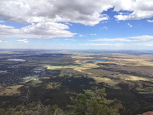
This challenging loop route ascends Bear Peak from the NCAR (National Center for Atmospheric Research) trailhead, offering rewarding 360-degree summit views and excellent fall foliage along the descent.


Hike
The trailhead is clearly marked at the NCAR facility with ample parking and restroom facilities available. The route begins with moderate terrain before turning onto the Fern Mountain Trail, where conditions become steep and rocky with significant elevation gain.
remove free decal offer
Note that Nebel Horn presents a difficult and potentially hazardous side trek - it's best avoided unless you're an experienced scrambler with extra time.

The final push to Bear Peak's summit intensifies with steep, rocky terrain requiring careful footing. A short scramble leads to the true high point, where you'll find two summit markers and panoramic views in all directions.

The return route continues the loop with a long descent through less-trafficked terrain. The trail offers beautiful fall colors when in season and passes near water sources marked on the route. Near the end, the trail forms a small secondary loop before a final climb back to the NCAR trailhead.

2025-09-29 ScaredyCat & HAZ_Hikebot


    Check out the Official Route and Triplogs.

    Note
    This is a more difficult hike. It would be unwise to attempt this without prior experience hiking.
    Leave No Trace and +Add a Triplog after your hike to support this local community.
    WARNING! Hiking and outdoor related sports can be dangerous. Be responsible and prepare for the trip. Study the area you are entering and plan accordingly. Dress for the current and unexpected weather changes. Take plenty of water. Never go alone. Make an itinerary with your plan(s), route(s), destination(s) and expected return time. Give your itinerary to trusted family and/or friends.

     Permit $$
    None


     Directions
    or
     Road
    Paved - Car Okay

    To hike
    Take a straight shot down Boulder Rd from Louisville, or take the 36 to Table Mesa from Boulder.
    page created by HAZ_Hikebot on Sep 29 2025 9:37 pm
    helpcorrectionissue

    end of page marker