 Route Editor

| Guide | ♦ | 2 Triplogs | 0 Topics |
details | drive | permit | forecast | route |
stats |
photos | triplogs | topics | location |
| 12 | 2 | 0 |
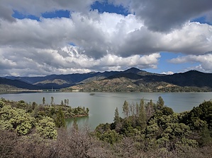
 Scenic coves with fishing and swimming opportunities. Plant identification plaques. Hikers only, no bicycles or horses. Warning Watch out for poison oak.
Starting at the south end of the trailhead, the path meanders in and out of small canyons. The first 1.5 miles of the path is well shaded and generally level, following an old irrigation ditch. Plant identification plaques have been placed along the trail. Look for big leaf maple and incense cedar, which are especially graceful trees. Benches noting trail distances have been placed along the trail. Stop and enjoy the view, looking north across the lake towards South Fork Mountain ( 3,447 feet). After about 2.0 miles, the trail descends to the lakeshore and winds along scenic sandy coves perfect for swimming and fishing. The trail follows the lakeshore for about 1.o miles, then gently climbs up a ridge to the trailhead at Brandy Creek Parking Lot B. History Historic mining activity can be seen at different locations on the trail. In this area, “coyote holes” were dug by miners in the late 1800s. There was just enough room for one miner to climb in with a pickaxe and a bucket. The gravel, dirt and gold were hauled up by a windlass and carried to a nearby stream for washing. Working inside the hole was the most dangerous type of gold mining - accidents frequently occurred from the caving-in of these diggings, which often did not have any shoring. Special Closures Portions of the trail may be closed to park visitors from January through July because of nesting Bald Eagles. Human activity disrupts reproduction of this threatened species. References National Park Service data sheets included within.
Check out the Official Route and Triplogs. Leave No Trace and +Add a Triplog after your hike to support this local community. One-Way Notice This hike is listed as One-Way. When hiking several trails on a single "hike", log it with a generic name that describes the hike. Then link the trails traveled, check out the example. | |||||||||||||||||||||||||||||||||||||||||||||||||||||||||||||||||||||||||||||||||||


