Route Editor

| Guide | ♦ | 20 Triplogs | 0 Topics |
details | drive | permit | forecast | route |
stats |
photos | triplogs | topics | location |
| 408 | 20 | 0 |
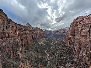
Great View of the Park! by KingLeonidas  Zion National Park boasts awe-inspiring landscapes, and the Canyon Overlook Trail provides a stunning introduction to its grandeur. This short and easy path follows Gifford Canyon/Pine Creek Gorge to a high point where you can see over the Mt Carmel Tunnel. It leads to a dramatic overlook, offering panoramic views of the Zion Canyon. Logistics/Getting There: The Canyon Overlook Trailhead is situated on the east side of Zion National Park, just east of the Zion-Mount Carmel Tunnel. From the Springdale Visitor Center, take Zion-Mount Carmel Highway towards the east entrance. After exiting the tunnel, look for the designated parking area and trailhead on your right. We entered the park from the and this was a great way to get a view of the Canyon before heading through the tunnel and onto the visitor's center.
The Canyon Overlook Trailhead has a small parking area with pit toilets. The trail is very popular and was crowded every time we attempted it or drove by. There is some additional parking along the side of rt 9 in the vicinity in certain areas, but this also was often full. Be prepared to drive around until someone leaves. Navigation: The trail is pretty clear in most sections with the steep drop-offs on one side and canyon wall on the other it isn't initially possible to get lost. Towards the end, the trail widens somewhat and some social trails go off the main track these appear to all end up at the viewpoint though so even following a social trail will probably get you to the viewpoint. Trail Conditions: The Canyon Overlook Trail is a well-maintained path. The initial section consists of a series of sandstone steps with a handrail guiding you up a rocky incline. The trail then continues through shaded alcoves with ferns and trees. Afterward, you'll encounter a short section of boardwalk before reaching the final ascent to the overlook. Most of the trail is narrow to the point of being single file which tends to cause traffic jams. The terrain is a mix of dirt paths, boardwalk, and some slickrock sections, none of which is technical. The entire trail is easily manageable for most hikers (which explains the mass appeal). General Comments and Musings: Despite its brevity, the Canyon Overlook Trail packs a punch in terms of scenic rewards. We were there on a partly cloudy day near sunset and the lighting was perfect (there was even a bit of snow on the higher peaks left). Keep an eye out for bighorn sheep, we saw an entire herd at the trailhead along Rt 9. They were completely indifferent to hikers and were doing some damage to the shrubbery that was starting to green up in the spring weather. This one is definitely worth doing if you are in the area, it is a quick hike so it is easy to sneak into the itinerary as a roadside stop when you are heading to or from the East entrance.
Check out the Official Route and Triplogs. Leave No Trace and +Add a Triplog after your hike to support this local community. | ||||||||||||||||||||||||||||||||||||||||||||||||||||||||||||||||||||||||||||||||||||||||||||||||||||||||||||||||||||||||||||||||||||||||||||||||||||||||||||||||||||||||||||||