username
X
password
register
for free!
help


Brown's Ranch Road Trail - MSPN, AZ

Guide 198 Triplogs  0 Topics
  2.9 of 5  
Fav
Wish
0
details
drive
no permit
forecast
route  
stats
photos
triplogs
topics
location
1.7k 198 0
HAZ reminds you to respect the ruins. Please read the Archaeological Resources Protection Act of 1979 & Ruins Etiquette
Statistics
tap row or icons for details
Difficulty 0.5 of 5
Route Finding 1 of 5
Distance One Way 2 miles
Trailhead Elevation 2,719 feet
Elevation Gain -76 feet
Accumulated Gain 67 feet
Avg Time One Way 1 hour
Kokopelli Seeds 2.22
 Interest Ruins & Historic
 Backpack Possible - Not Popular
feature photo
Photos Viewed All MineFollowing
Will recalculate on button tap!
15  2025-08-30
Brown's Mountain Summit via Upper Ranch
DarthStiller
22  2025-06-14
Upper Ranch Trail - MSPN
DarthStiller
12  2024-12-05
Brown's Ranch
LosDosSloFolks
8  2024-11-04 Sun_Ray
17  2024-09-21
Brown's Mountain Loop - MSPN
tibber
3  2024-01-11
McDowell Sonoran Preserve North
trekkin_gecko
6  2024-01-11
McDowell Sonoran Preserve North
johnlp
9  2023-12-12
Browns Ranch
The_Eagle
Page 1,  2,  3,  4,  5 ... 13
Author
author avatar Guides 31
Routes 135
Photos 2,699
Trips 615 map ( 2,220 miles )
Age 52 Female Gender
Location Scottsdale, AZ
Associated Areas
list map done
Phoenix Region
Historical Weather
Trailhead Forecast
Radar Map
Expand Map
Preferred Mar, Apr, Jan, Feb → Early
Seasons   Early Autumn to Early Summer
Sun  6:04am - 6:48pm
Official Route & 5 Rts
 
59 Alternative


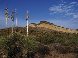
Human history in the McDowells
by Crzy4AZ

 
The Brown’s Ranch Road segment is the main artery leading out of the Brown’s Ranch trailhead and connects with dozens of other trails in the newly developed northern region[1] of the McDowell Sonoran Preserve. The trailhead opened June 10, 2013, but the official opening ceremony will be October 19th.


The sandy, flat path has been used by desert dwellers including ancient Hohokam and more recently mid-century ranchers. In fact, the stretch of road from Dynamite Boulevard to the parking lot is the exact route for cattle drives that ran from the ranch into Scottsdale until the 1960s. Archaeologist Thomas Wright published Brown’s Ranch site info that dates the earliest evidence of human existence to 7000 B.C.[2,3] Much later the land was seasonally irrigated for agriculture by the Hohokam from 500 B.C. to 1300 A.D. The Brown family purchased the land in 1917 and it was a working ranch until 1970. At its peak, Brown’s Ranch encompassed 44,000 acres supporting 3,000 to 5,000 head of cattle.[2,4] The land was acquired in 1999 by the City of Scottsdale and the project to develop the trails and trailhead cost 3.8 million dollars funded by a 2004 Preserve Sales Tax.
remove free decal offer
From the trailhead, after you read more details of the history of the area follow signs for Brown’s Ranch Road trail. The trail segment is 2 miles one way and is an easy, wide path ideal for trail running, biking, and horseback riding. Add elevation gain to this segment at 0.4 miles from trailhead going northwest up to Brown’s Mountain trail and summit (marker #BT1). Watch for the intersection with the Corral Trail at 1.4 miles (marker #CL1) for the turnoff to the right to see the ruins of the Brown’s Ranch including the footprint of the northern ranch house, corrals, stock tanks, blacksmith’s shed, bunkhouse, and other structures.

If you are looking for larger loops, connect with trails leading to Cholla Mountain and Little Granite Mountain. There are plans underway to connect these northern McDowell region trails with the more mountainous southern region trails (Windgate, Bell, Quartz, Sunrise)[1]. The Maricopa Trail will eventually connect 420 miles of trails in 10 parks throughout Phoenix and Scottsdale including both southern and northern regions of the McDowell Sonoran Preserve.

References


  1. Mountain Lines Vol 20(1), Fall 2013. McDowell Sonoran Conservancy magazine.

  2. From educational plaques at Brown’s Ranch trail head

  3. Wright TE., The Arizona Archaeologist;2002, “Archaeological testing of AZ U:1:25 (ASM), the Brown's Ranch Rock Shelter site, in northern Scottsdale, Maricopa County, Arizona “.


2013-09-12 Crzy4AZ
  • MSPN Brown Insert
    area related
    MSPN Brown Insert
  • MSPN Trail List
    area related
    MSPN Trail List
  • MSPN Gate Schedule
    area related
    MSPN Gate Schedule
  • MSPN 2021 Map
    area related
    MSPN 2021 Map
  • MSPN 2021 Details
    area related
    MSPN 2021 Details


Check out the Official Route and Triplogs.
Leave No Trace and +Add a Triplog after your hike to support this local community.

One-Way Notice
This hike is listed as One-Way.

When hiking several trails on a single "hike", log it with a generic name that describes the hike. Then link the trails traveled, check out the example.
WARNING! Hiking and outdoor related sports can be dangerous. Be responsible and prepare for the trip. Study the area you are entering and plan accordingly. Dress for the current and unexpected weather changes. Take plenty of water. Never go alone. Make an itinerary with your plan(s), route(s), destination(s) and expected return time. Give your itinerary to trusted family and/or friends.

 Permit $$
None


 Directions
or
 Road
Paved - Car Okay

To Brown's Ranch Trailhead
From the 101 in North Scottsdale, drive North on Pima/Princess drive and go East on Happy Valley Road to the stop sign at the instersection of Happy Valley & Alma School Road. Follow Alma School Road North past Dynamite until it ends at Brown's Ranch Trailhead.

From PHX (I-10 & AZ-51) 34.0 mi - 44m
From TUC (Jct 1-10 & Grant) 135 mi - 2h 4m
From FLG (Jct I-17 & I-40) 139 mi - 2h 15m
 90+° 8am - 6pm kills
helpcorrectionissue

end of page marker