 Route Editor

| Guide | ♦ | 52 Triplogs | 0 Topics |
details | drive | no permit | forecast | route |
stats |
photos | triplogs | topics | location |
| 505 | 52 | 0 |
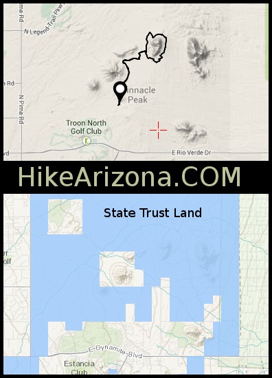
Genteel ramble by Nan   Cholla Mountain Loop is a genteel ramble through the open desert of the proposed McDowell Mountain Preserve. It crosses the current preserve land, rounds Cholla Mountain (Hill #3406 on the SLD's "Granite Mountain Multiuse Area" map) and returns, covering a boulder-and-saguaro-dotted landscape. Except for one very short, steep climb and descent, the grade is easy. There's NO shade, so this is not a summer hike. Cholla Mountain Loop is a genteel ramble through the open desert of the proposed McDowell Mountain Preserve. It crosses the current preserve land, rounds Cholla Mountain (Hill #3406 on the SLD's "Granite Mountain Multiuse Area" map) and returns, covering a boulder-and-saguaro-dotted landscape. Except for one very short, steep climb and descent, the grade is easy. There's NO shade, so this is not a summer hike.Not much info is available on the trail system in the McDowells. No doubt because the Preserve's future is still in limbo, so I figured the best way to find out was one of the McDowell-Sonoran Conservancy's free guided hikes. We set out from the TH about 7:30, heading north on TR 27. At this point, it's more of a road than a trail. The MSC volunteers who do maintenance have put up stick barriers and scattered cholla buds at some points alongside the trail to discourage people from going cross-country. Most of this hike is on State Trust Land, so look out for motorbikes and ATVs.
Turn left on TR 24. The trail starts to undulate, and there are several turns; follow the trail markers. On this day, the fairy dusters and hedgehogs were giving a good show. Climb up the shoulder of Cholla Mountain to Gorilla Rock... this is the one serious grade in the hike, and you're probably ready for a good ankle-stretcher by now. A few hundred feet on is another group of boulders, so have a rest and a snack and enjoy the view of Carefree and points north. At the bottom of the downslope, turn right on TR 28, that takes you around the back of Cholla Mountain, and right again on TR 30. A pair of rock climbers were trying their luck as we passed through. This is the stretch where you figure out how the hill got its name. On a right-hand spur, just after you pass through the Ocotillo forest, there's a natural amphitheater that makes an interesting detour. TR 30 T's into TR 24; turn right, and a few yards further on, turn left on the unmarked trail. This takes you back into the Preserve. After some undulating and crossing a sandy wash, the trail Ts back into TR 27, right in front of Brown's Mountain. Turn left and walk out to the TH. No water or toilets at the TH, but there is a cleverly-disguised gas station on the SW corner of Alma School and Dynamite. Gate Policy: If a gate is closed upon arrival, leave it closed after you go through. If it is open, leave it open. Leaving a closed gate open may put cattle in danger. Closing an open gate may cut them off from water. Please be respectful, leave gates as found. The exception is signage on the gate directing you otherwise.
Check out the Official Route and Triplogs. Leave No Trace and +Add a Triplog after your hike to support this local community. | |||||||||||||||||||||||||||||||||||||||||||||||||||||||||||||||||||||||||||||||||||||||||||||||||||||||||||||||||||||||||||||||||||||||||||||||||||||||||||||||||||||||||||||||||||||


