 Route Editor

| Guide | ♦ | 7 Triplogs | 0 Topics |
details | drive | no permit | forecast | route |
stats |
photos | triplogs | topics | location |
| 55 | 7 | 0 |
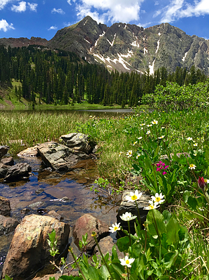
In Twilight's Shadow by chumley Hike: The hike begins on the south side of the popular Andrews Lake. Follow the paved multiuse path over the bridge before turning onto dirt single-track near the first fishing dock and heading up a gentle slope to the informational signs indicating the start of the trail.
Once reaching the crest of the initial climb, you pass a trail junction with a forest service register box. The trail to the left leads across a picturesque meadow with a couple of ponds before ascending to the summit of Snowdon Peak. Go straight here to continue to Crater Lake. This is probably a spot where many take in the view and return to the lake. From here the trail is single-track. Over the next .75 mile the trail descends about 200 feet through a draw to a small drainage, which will be running with water during snowmelt or after wet weather. There are excellent views to the north and the peaks near Silverton, while Engineer dominates the southwest view. At about the 2 mile mark, the trail begins a short and steep climb of about 400 feet in half a mile as you cross the signed boundary and enter the Weminuche Wilderness. All normal wilderness regulations apply ... no bikes or other mechanized transport, and a group limit of 15. At the 2.5 mile mark, the trail descends again, dropping about 300 feet over the next half mile, crossing the upper reaches of Three Lakes Creek along the way. Next, the trail climbs gently but steadily over the next 2.5 miles, passing through open meadows with views of Engineer and North Twilight Peaks as well as shaded pine forest. Summer will bring ample wildflowers to the grassy meadows, and early season will provide views of snow capped peaks. A couple of areas of deadfall provide an occasional obstacle, but the trail is well-maintained and most trees should be cleared from the trail. After 5.4 miles the trail reaches the high-point before dropping slightly to a small marshy pond. The final half mile meanders southward, and gently descends to the picturesque shore of Crater Lake. Once reaching the lake, you may return the way you came, or you can explore the use trails that head in both directions around the lake. Circling the lake completely will add a little over half a mile. Connecting Options: As indicated above, this trail can be used to access Snowdon Peak. Additionally, from the end of the trail at Crater Lake, there is a well-worn path that leads to North Twilight Peak and other undeveloped destinations in the West Needle Mountains. Camping: Camping is permitted in the Weminuche Wilderness but there are restrictions to camping close to Crater Lake. All camps must be 100 feet or more from the shore, and campers should use existing fire rings when possible. There are several posts near the lake that prohibit camping in specific areas. Please observe signs and restrictions. Water Sources: Crater Lake provides drinkable water as do numerous stream crossings along the trail. All water should be treated prior to drinking. Fishing: Fly and spin-casting are permitted at Crater Lake and it is rated fair for cutthroat trout. Check with Colorado Parks and Wildlife for permit and limits. Weather: As with most high-elevation summer hikes, the weather is likely to be better in the morning. By noon showers and thunderstorms are common and can develop rapidly. Check out the Official Route and Triplogs. Leave No Trace and +Add a Triplog after your hike to support this local community. One-Way Notice This hike is listed as One-Way. When hiking several trails on a single "hike", log it with a generic name that describes the hike. Then link the trails traveled, check out the example. | |||||||||||||||||||||||||||||||||||||||||||||||||||||||||||||||||||||||||||||||||||||


