Route Editor

| Guide | ♦ | 3 Triplogs | 0 Topics |
details | drive | permit | forecast | route |
stats |
photos | triplogs | topics | location |
| 26 | 3 | 0 |
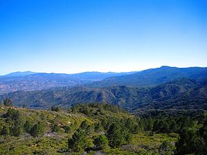
remarkably clear skies by PLC92084 With over 25 miles of hiking trails, the Agua Tibia was established as a wilderness on January 3, 1975. This 15,933-acre area is mountainous and cut by many deep canyons containing only intermittent streams. Vegetation is mostly chaparral with oak woodlands and some coniferous forests at the higher elevations. Small pools of water in the canyon bottoms become warm in summer months and thus the name Agua Tibia. Summer temperatures may exceed 100 degrees in the canyons and on the slopes, but are a moderate 80-90 degrees at upper elevations.
We started our trek at 0715 hours while it was still pretty cool (low 40's). It didn't take long to warm up enough to lose our jackets. We spent the morning ascending the Crosley Saddle/Dripping Springs Trail (approx 8.5 mi, 3200" AEG), stopping for lunch on Agua Tibia Peak (elev. 4779'). Getting to Agua Tibia involved some bushwhacking (about a 1/4 -mile worth) because the "trail" up to it isn't highly traveled. The "turnoff/junction" can be easily missed if one isn't careful; watch for a small cairn on the left (south?) side of the trail. Once we made it up, I was glad we took the time to do it. The remarkably clear skies allowed us to easily see San Clemente and Santa Catalina Islands to the west (about 60 miles as the gull flies). Lake Elsinore, to the North a good 20 miles, was also very easy to locate. Not so obvious was the bright red registry can tucked into a crevice as though no one actually wanted us to find it (it's like this is a major peak...). I talked myself into signing it, since I was there (then shamelessly plugged HAZ!) [...like an idiot, I neglected to recruit those in my party with cameras to document it ] After lunch was finished, we made it back down to the trail and headed for Crosley Saddle (elev. 3931') and the Wildhorse Trail junction. This section was about 11/2 miles according to my GPS track data. Because the trail was pretty overgrown with vegetation and dead trees (from the fire in 2006, I believe...), it seemed longer. Navigating this section wasn't the most enjoyable experience - but it wasn't the worst, either. I was thinking the whole time what a piece of cake it was compared to bushwhacking in AZ with Cholla, Cat Claw and the like! Most of the folks I was with had no idea. Some enterprising soul had been through this way previously and marked the path with orange marking tape so it wasn't too difficult to stay on track (with one notable exception)... About a half-mile or so from Crosley Saddle, the markers weren't readily observable so it was necessary to rely on GPS and maps (unbelievably, I was the only one with a Topo map and one of two with a GPS unit on this outing!). We wound up taking the "scenic tour" about a 1/4 mile down a ridge that looked like it might go in the direction we wanted. It didn't... I re-stated my case and explained, again, that we were shy of the actual trail. Everyone re-traced their steps and we followed the real route to the trail junction. The sign marking it was in several pieces on the ground because it had been burned in the fire from a few years back. The remainder of the hike was pretty straight-forward. The Wildhorse segment was in much better condition than the trail we had been following so the last half of the hike was a bit more enjoyable. We stopped at a flowing creek for a brief respite then continued on to finish our trip. We rolled into the parking lot around 1715 hours. All-in-all, the day had been very pleasant, the hike enjoyable. Because of the seasonal availability of water, it is strongly suggested one drink and bring plenty with them. Check out the Official Route and Triplogs. Leave No Trace and +Add a Triplog after your hike to support this local community. | ||||||||||||||||||||||||||||||||||||||||||||||||||||||||||||||||||||||||||||||||||||||||||||||