Route Editor

| Guide | ♦ | 26 Triplogs | 0 Topics |
details | drive | permit | forecast | route |
stats |
photos | triplogs | topics | location |
| 437 | 26 | 0 |
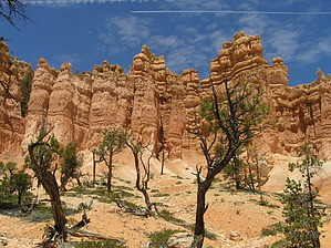
I'm going to Fairyland!!! by Trishness We started from Fairyland Point at 12:30 PM and hiked this clockwise immediately starting a 600-foot descent into the canyon in the first mile and a half. Terrific views of Sinking Ship and Boat Mesa reward you as you descend through Douglas Fir, juniper, and Bristlecone pine. There are some truly beautiful photo ops through this area. You will then cross a wash area and continue down into the canyon. The trail is easy to follow and is just an up and down hike through some gorgeous vistas....sheer rock cliffs of Boat mesa off to your right and some really astounding hoodoos along the way. I'm entranced by THIS fairyland. Several more wash crossings and suddenly you are heading back uphill. Not a huge climb but a climb all the same......AND true to our trip these last 2 weeks, we have gusty winds which threaten to blow my hat off at every exposed area. There are some beautiful vistas of Fairyland Canyon when top off here. You then descend a bit more as you reach the intersection of Tower Bridge where you can take a little spur trail to the bridge. We opted not to do this today but probably should have just gone. It is 4 miles from Fairyland Point to the Tower Bridge intersection. Once here, it is an uphill climb of 800 feet in 1.5 miles to Sunrise Point but the terrain and rock formations are amazing.....the Chinese Wall is on your left. After topping off near Sunrise Point (elev 8017), you then take the Rim Trail back to Fairyland Point, another 2.5 miles but a gentle one along the rim of Bryce Canyon.
I highly recommend this as a "must-do" when in Bryce Canyon~~~~While it doesn't have the same WOW factor that the Navajo Loop through Wall Street does, it still packs a wallop and the views are just awesome.
Check out the Official Route and Triplogs. Leave No Trace and +Add a Triplog after your hike to support this local community. | ||||||||||||||||||||||||||||||||||||||||||||||||||||||||||||||||||||||||||||||||||||||||||||||||||||||||||||||||||||||||||||||||||||||||||||||||||||||||||||||||||||||||||||||||||||