Route Editor

| Guide | ♦ | 7 Triplogs | 0 Topics |
details | drive | permit | forecast | route |
stats |
photos | triplogs | topics | location |
| 32 | 7 | 0 |
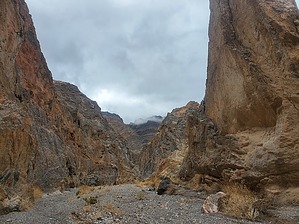
It's a not waterfall by ShatteredArm Fall Canyon is a narrow, steep-walled canyon following a fault line through the Grapevine Mountains in Death Valley National Park. NPS recommends this hike for those looking for a little bit longer of an adventure. The canyon is named after the dry fall at the end of the official route. Fall Canyon runs roughly parallel to Titus Canyon, where one-way high clearance vehicle traffic is allowed much of the time.
The hike begins at the end of the one-way stretch of Titus Canyon Road, three miles up the dirt road from Scotty's Castle Road (this road is easily navigable by all but low clearance vehicles). Here, at the mouth of the Titus Canyon narrows, there is a small parking area and a restroom, as well as an information sign. Follow the trail from behind the restroom in a northwesterly direction. After a short distance, the trail crosses over a wash heading to the right and then continues up the wash straight ahead. The trail isn't terribly obvious here, but as long as you stay in the larger wash, you should be fine. You contour around the base of the mountain for half a mile before you enter Fall Canyon, which at this point is a wide, flat wash heading down the alluvial fan. Head upstream from here, and within a half-mile you reach a short narrow part of the canyon. There won't be a well-defined trail the rest of the way, but it should be fairly obvious which direction to go. After a mile and a half or so, the canyon bends almost due north for a long open stretch, where you'll be treated to views of high walls with some interesting geological formations. Early in this stretch there is a short slot canyon on the left that is worth the very small investment. At around 2.5 miles, you'll take a nearly right-angle turn to the east, and notice the canyon is pretty narrow again. Here you'll find the first stretch that might be prohibitive to vehicles passing through. The walls are now towering over 1,000 feet above the bottom of the canyon, and you'll soon arrive at the namesake fall. You can sit for a bit and turn back the way you came, or, if you're able to scramble past the pour-off (which is not trivial), you can explore farther up the canyon. Water Sources There are no water sources along this route. Camping The nearest campgrounds are Mesquite Spring 22.5 miles to the Northwest, and Stovepipe Wells 25 miles to the south. Dispersed camping is not allowed in this area. Backcountry camping along the trail is legal as long as you are more than a mile from the nearest road. Check out the Official Route and Triplogs. Leave No Trace and +Add a Triplog after your hike to support this local community. | ||||||||||||||||||||||||||||||||||||||||||||||||||||||||||||||||||||||||||||||||||||||