Route Editor

| Guide | ♦ | 3 Triplogs | 0 Topics |
details | drive | no permit | forecast | route |
stats |
photos | triplogs | topics | location |
| 49 | 3 | 0 |
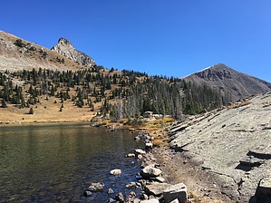
More than Four by arizona_water Fourmile Creek is a fun and moderately challenging hike north Pagosa Springs, CO. The hike can be done without snow, as early as late June and as late as November. The trail passes several large waterfalls and ends at a mountain lake, with the option of continuing to an alpine lake at 11,670ft. Hike Starting at the Fourmile Trailhead, an obvious trail marker leads N/NE through an aspen grove. The trail is easy to follow but may be overrun with snowmelt and mud depending on the time of year.
There are great backpacking options from this trail. You can camp at either Lower or Upper Fourmile Lakes, maintaining wilderness restrictions of camping no closer than 200ft from a water source. Layout 4.35-miles along Fourmile Stock Drive Trail #569. Left on Anderson Trail #579 1.1-miles to Fourmile Lake. Then 0.2-miles off-trail along the creek to Upper Fourmile Lake. Check out the Official Route and Triplogs. Note This is a moderately difficult hike. Leave No Trace and +Add a Triplog after your hike to support this local community. | |||||||||||||||||||||||||||||||||||||||||||||||||||||||||||||||||||||||||||||||||||||